IMAGES TAKEN NEAR TO
St. Catherines, LINCOLN, LN5 8LY
Introduction
This page details the photographs taken nearby to St. Catherines, LN5 8LY by members of the Geograph project.
The Geograph project started in 2005 with the aim of publishing, organising and preserving representative images for every square kilometre of Great Britain, Ireland and the Isle of Man.

There are currently over 7.5m images from over14,400 individuals and you can help contribute to the project by visiting https://www.geograph.org.uk
Image Map
Images are licensed for reuse under creativecommons.org/licenses/by-sa/2.0
Notes
- Clicking on the map will re-center to the selected point.
- The higher the marker number, the further away the image location is from the centre of the postcode.
Image Listing (99 Images Found)
Images are licensed for reuse under creativecommons.org/licenses/by-sa/2.0
Image
Details
Distance
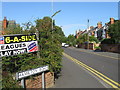
1
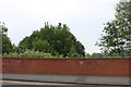
Bridge over disused railway line on London Road
The old trackbed is now thick with woodlands
Image: © David Howard
Taken: 24 Jun 2019
0.04 miles
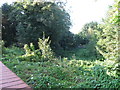

7
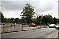
Site of the Eleanor Cross
The tree in the centre stands near the point where Lincoln's Eleanor cross once stood on Swine Green, at the junction of Cross-o-Cliff Hill and Newark Road.
Following the death of Queen Eleanor in Harby, Notts. on 28th November 1290, King Edward I erected an 'Eleanor Cross' at each of the places her funeral cortege stayed overnight on the way to Westminster.
Records show that it was repaired by the City authorities in 1624, though it was destroyed during The Civil War about 20 years later. A fragment of a statue of Eleanor was rescued from its use as a footbridge in the 19th century and can now be seen in Lincoln Castle grounds.
Image: © Richard Croft
Taken: 9 Sep 2007
0.06 miles
8
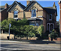
49-51 St Catherines, Lincoln
Pair of semi detached houses built by M Hampshire to planning approved March 1885. 49 has the nameplate 'Cliffside'. No.49 is listed as a 5 bedroom semi-detached house. Sold in the February, the 2,120 sq ft 4 bedroom no.51 had planning approved for a single storey rear extension with balcony in July 2021.
Image: © Jo and Steve Turner
Taken: 25 Nov 2022
0.06 miles
10
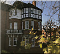
Ferncliffe House, 2 St Catherines, Lincoln
Not the best picture but it is difficult to photograph. House built for Alderman Thomas Wallis, architect W Mortimer and Son to planning approved in July 1896. Wallis made additions in 1907 and a dispensing room by builder W Challands in 1911. Presumably from about 1911, the house is occupied by Major Osmand Harry Chapman MD RAMC surgeon until at least 1919. In 1913 Ruddock's directory calls it Fernville. Planning was granted in October 2015 for 54m of 1.95m high wrought iron railings and gate to front elevation.
Image: © Jo and Steve Turner
Taken: 25 Nov 2022
0.06 miles