IMAGES TAKEN NEAR TO
Dunford Road, LINCOLN, LN5 8HF
Introduction
This page details the photographs taken nearby to Dunford Road, LN5 8HF by members of the Geograph project.
The Geograph project started in 2005 with the aim of publishing, organising and preserving representative images for every square kilometre of Great Britain, Ireland and the Isle of Man.

There are currently over 7.5m images from over14,400 individuals and you can help contribute to the project by visiting https://www.geograph.org.uk
Image Map
Images are licensed for reuse under creativecommons.org/licenses/by-sa/2.0
Notes
- Clicking on the map will re-center to the selected point.
- The higher the marker number, the further away the image location is from the centre of the postcode.
Image Listing (65 Images Found)
Images are licensed for reuse under creativecommons.org/licenses/by-sa/2.0
Image
Details
Distance
1
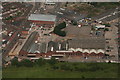
Former industrial premises,now trading estate east of A15, Lincoln: aerial 2016
North of South Common.
Image: © Chris
Taken: 24 Jun 2016
0.02 miles
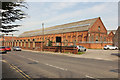
2
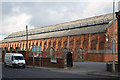
Robey Works
Large industrial building at the former Robey Works off Canwick Road
Image: © Richard Croft
Taken: 1 Nov 2010
0.06 miles
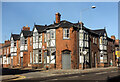
3
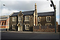
The Chaplin Arms
Tudor revival, grade II listed, mid 19th century former public house on Canwick Road
Image: © Richard Croft
Taken: 1 Nov 2010
0.06 miles
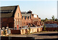
4
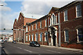
Robey Works
Classical frontage of the former Robey Works on Canwick Road, now Jackson's builders merchants
Image: © Richard Croft
Taken: 1 Nov 2010
0.07 miles
5
Canwick Road
Former Robey Works on Canwick Road
Image: © Richard Croft
Taken: 19 Apr 2019
0.08 miles
7
Old Robey works, Lincoln from old railway bed off Canwick Road
Along the southern edge of Jackson’s site (and Robey’s after the railway cut it off) are a row of twelve gable ends. All are apparently shown on the 1886-1889 OS map and all probably existed by 1882. The first bay on the Canwick road side is parallel to the road and shows indications of being raised in height by 8 or 10 brick courses (2ft?). The southern end of this bay for the reasons about to be explained has probably been truncated and rebuilt to align with the eleven remaining bays that align to the southern boundary. The 6.75 acres previously part of the Cow Paddle inside the Lincoln and Honington Branch Line was almost certainly purchased by Robey’s in 1869-70 but they will have known that it was to be cut off by the avoiding line from 1879 if not before. I suspect therefore the Canwick Road end bay was probably early 1856-64 date and the remaining bays 1879 to 1886. A planning application exists for ‘extensions’ in 1881. The second bay from the west, due to the differing alignment tapers off into the western most bay. Aside from the five eastern bays that abut the larger east/west bays all the gable walls to the north also appear largely original. The last five bays were truncated by the east/west bay built 1918-1948. All fenestration appears to have been modified or bricked up. A 1916 picture of aircraft wing production shows a bay with monitor roof as two of the bays in the centre of this collection.
Image: © Jo and Steve Turner
Taken: 16 Nov 1989
0.09 miles
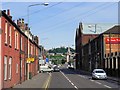
8
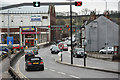
Canwick Road
The A15, one of the main routes into Lincoln from the south with a 'tidal' traffic flow system. Here, two lanes in and one out, though this alters to accommodate changes in traffic volume. The opposite view to http://www.geograph.org.uk/photo/2746195
Image: © Richard Croft
Taken: 31 Dec 2011
0.09 miles
9
95 Canwick Road, Lincoln
Planning was approved in September 1883 for Robey & Co. to build this as a coffee palace. Architect was listed as ‘self’ indicating Robey staff. They also had ‘additions to’ planning approved in April 1919 with Watkins & Son architects. It seems to have been operated under different guises and is listed in directories as; 1885 No.81 Canwick Road William Jackson, coffee house; 1889 No.79 Canwick Road William Jackson, coffee rooms; 1894-1897 Globe Coffee Tavern, proprietor J R Hatton; 1901 now No.95, proprietors J R Hatton and Son; 1905 R Hatton Jn., coffee rooms; 1909-1913 manager Richard B Skelton; 1919 (Ruddock’s) Globe Coffee Tavern, manager Harry Wadland. (Kelly’s) Robey & Co., canteen; In 1965 it was listed just as Robey & Co. Ltd. but I remember around this time it was known as Robey’s Club and is referred to as such by the band ‘Salvador’ in August 2002. About 2003 to 2005 it was Sirens Gentleman’s Club. It was sold in 2007 (probably to Tendgrain Ltd.) and in 2009 looked to have been converted to 1-11 Globe House but partly unoccupied. By 2011 it looked fully refurbished.
Image: © Jo and Steve Turner
Taken: 16 Nov 1989
0.09 miles
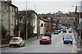
10
Canwick Road
View south along Canwick Road from Pelham Bridge, the opposite view to http://www.geograph.org.uk/photo/2746191
Image: © Richard Croft
Taken: 31 Dec 2011
0.10 miles