IMAGES TAKEN NEAR TO
South Park, LINCOLN, LN5 8EW
Introduction
This page details the photographs taken nearby to South Park, LN5 8EW by members of the Geograph project.
The Geograph project started in 2005 with the aim of publishing, organising and preserving representative images for every square kilometre of Great Britain, Ireland and the Isle of Man.

There are currently over 7.5m images from over14,400 individuals and you can help contribute to the project by visiting https://www.geograph.org.uk
Image Map
Images are licensed for reuse under creativecommons.org/licenses/by-sa/2.0
Notes
- Clicking on the map will re-center to the selected point.
- The higher the marker number, the further away the image location is from the centre of the postcode.
Image Listing (138 Images Found)
Images are licensed for reuse under creativecommons.org/licenses/by-sa/2.0
Image
Details
Distance
2
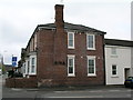
Lincoln, South Park
The end of terrace carries a cut bench mark. See http://www.geograph.org.uk/photo/3025598 for a close-up.
Image: © Brian Westlake
Taken: 2 May 2012
0.05 miles
3
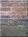
Cut bench mark on 15 South Park
See http://www.geograph.org.uk/photo/3025590 for a wider view and http://www.bench-marks.org.uk/bm43790 for details on the bench mark.
Image: © Brian Westlake
Taken: 2 May 2012
0.05 miles
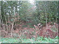
4
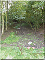
Old railway cutting
Overgrown former railway cutting near the South Common
Image: © Richard Croft
Taken: 22 Sep 2010
0.05 miles
5
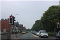
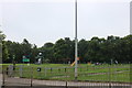
Pedestrian crossing on South Park, Lincoln
Image: © David Howard
Taken: 24 Jun 2019
0.05 miles
6
The former Great Northern line to Honington Junction
This line opened in 1867 and closed to passengers in 1965. All traffic ceased in 1969 except for a short section to Lincoln Gasworks which closed a year later.
Image: © Jonathan Thacker
Taken: 8 Oct 2011
0.06 miles
7
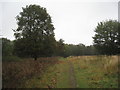
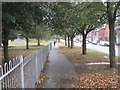
South Common
Looking towards the former Lincoln to Grantham railway line.
Image: © Jonathan Thacker
Taken: 8 Oct 2011
0.06 miles
8
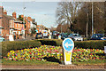
South Park
Spring flowers on the roundabout at Great Bargate and view along South Park
Image: © Richard Croft
Taken: 7 Mar 2012
0.07 miles
9
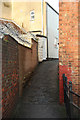
Little Bargate
Cobbled passage from the bridge over Sincil Dike to Spencer Street, site of the late 13th / early 14th century Little Bargate, one of the gates to the lower medieval City. Courses of medieval stone can be seen in the wall to the left.
Image: © Richard Croft
Taken: 15 Dec 2012
0.07 miles
10
South Park Avenue
Looking towards the High Street and St. Catherine's. South Common on the left.
Image: © Jonathan Thacker
Taken: 8 Oct 2011
0.08 miles