IMAGES TAKEN NEAR TO
South Park Avenue, LINCOLN, LN5 8EL
Introduction
This page details the photographs taken nearby to South Park Avenue, LN5 8EL by members of the Geograph project.
The Geograph project started in 2005 with the aim of publishing, organising and preserving representative images for every square kilometre of Great Britain, Ireland and the Isle of Man.

There are currently over 7.5m images from over14,400 individuals and you can help contribute to the project by visiting https://www.geograph.org.uk
Image Map
Images are licensed for reuse under creativecommons.org/licenses/by-sa/2.0
Notes
- Clicking on the map will re-center to the selected point.
- The higher the marker number, the further away the image location is from the centre of the postcode.
Image Listing (115 Images Found)
Images are licensed for reuse under creativecommons.org/licenses/by-sa/2.0
Image
Details
Distance
1
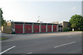
Lincoln South fire station
Lincoln South fire station, South Park Avenue, Lincoln, Lincolnshire
Image: © Kevin Hale
Taken: 31 May 2008
0.01 miles
2
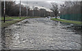
Flooded South Park Avenue (A15)
Ironically outside the Fire Station and Ambulance Station.
Image: © J.Hannan-Briggs
Taken: 25 Dec 2012
0.03 miles
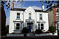
3
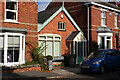
46 South Park, Lincoln
Probably on a plot that was a coach-building workshop for Henry Cotton, painter and coach-builder, who lived at 45 South Park (previously, 1885-1895, 1 Sussex Terrace). The present building was a paint shop for C Cotton built in 1923. It was converted into residential use in 2006 and an archaeological watching brief at the time found only modern features, including a large pit, a brick interceptor chamber and drainage pipe.
Image: © Jo and Steve Turner
Taken: 2 Oct 2015
0.05 miles
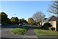
4
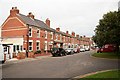
South Park
Victorian houses overlooking the South Common
Image: © Richard Croft
Taken: 15 Sep 2008
0.06 miles
5
Old South Park Avenue
Moss covered road approaching the railway bridge on the former South Park Avenue
Image: © Richard Croft
Taken: 15 Sep 2008
0.06 miles
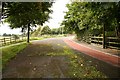
6
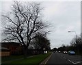
South Park Avenue
Road forming the northern border of South Common. Looking west towards the Fire Station (on right)
Image: © John Myers
Taken: 28 Oct 2014
0.07 miles
7
View in the rain
Looking across the field of Edward King school with the east stand of Sincil Bank Football Ground and the Cathedral in the background.
Image: © Jonathan Thacker
Taken: 8 Oct 2011
0.07 miles
8
51 South Park, Lincoln
Known as Guildford House it was built for John Holton, architect William Mortimer to planning approved in September 1882. For over 20 years until around 2013 it was at first Low Fields Acupuncture and then Ch'ien Acupuncture clinic.
Image: © Jo and Steve Turner
Taken: 2 Oct 2015
0.07 miles
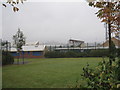
10
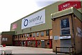
The rear of the Selenity Stand at the LNER Stadium
The LNER Stadium is home to Lincoln City F.C.
Image: © Steve Daniels
Taken: 12 Sep 2020
0.07 miles