IMAGES TAKEN NEAR TO
Colegrave Street, LINCOLN, LN5 8DR
Introduction
This page details the photographs taken nearby to Colegrave Street, LN5 8DR by members of the Geograph project.
The Geograph project started in 2005 with the aim of publishing, organising and preserving representative images for every square kilometre of Great Britain, Ireland and the Isle of Man.

There are currently over 7.5m images from over14,400 individuals and you can help contribute to the project by visiting https://www.geograph.org.uk
Image Map
Images are licensed for reuse under creativecommons.org/licenses/by-sa/2.0
Notes
- Clicking on the map will re-center to the selected point.
- The higher the marker number, the further away the image location is from the centre of the postcode.
Image Listing (127 Images Found)
Images are licensed for reuse under creativecommons.org/licenses/by-sa/2.0
Image
Details
Distance
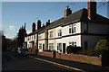
1
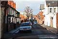
Weir Street
Edwardian houses in St.Catherine's
Image: © Richard Croft
Taken: 7 Mar 2012
0.02 miles
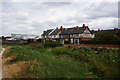
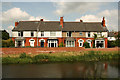
2
St.Catherine's Terrace
Houses in St.Catherine's by the River Witham
Image: © Richard Croft
Taken: 22 Sep 2010
0.03 miles
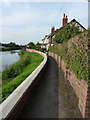
3
River Witham
Looking south from Altham Terrace on a flooded River Witham
Image: © Richard Croft
Taken: 22 Jul 2007
0.05 miles
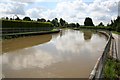
4
Houses overlooking the River Witham near Boultham
Image: © Ian S
Taken: 18 Jul 2018
0.05 miles
5
Wyatt Road
Quiet, residential area of St.Catherine's near the River Witham
Image: © Richard Croft
Taken: 7 Mar 2012
0.05 miles
6
St.Catherine's Terrace
The four houses that make up St.Catherine's Terrace http://www.geograph.org.uk/photo/2079135 seen across the River Witham
Image: © Richard Croft
Taken: 14 Jun 2012
0.05 miles
7
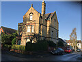
1 St Catherine's Road, Lincoln
Large detached house named Southfield and built 1891 (name/date plaque - planning approved Oct 1890) for Thomas Wallis JP Timber Merchant and one-time alderman, by architect W Mortimer. Thomas is still listed here in my 1919 directory. Southfield had a large garden (c.2000 sq m - 0.5 acres) between Derby and Weir Streets on which was built 2-5 St Catherines Road, the Coach House and 5 Weir Street (all seem to be on the 1920 map). At least two plans for various housing arrangements had been made prior to Southfield but not implemented. The Coach House was built as a stable for Southfield and later converted to residential.
Image: © Jo and Steve Turner
Taken: 25 Nov 2022
0.05 miles
8
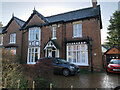
15 St Catherine's Road, Lincoln
Thornton Villa and its semi detached partner was built by Joseph Copley to planning approved February 1883. Copley appears to have occupied no.16 (originally no.3) until at least 1894 as in 1897 a Mrs Copley is listed here. Contractor Thomas Lane seems to have been an early, probably first, occupant of no.15 (originally no.4). A garage and house 'alterations' for J Howitt were approved by planning in July 1930, architect John Davis (Diocesan Surveyor for Lincoln). The Hewitt's were in Norton Villa (no.14) until at least 1901 but the family then lived at no.15 until at least 1965.
Image: © Jo and Steve Turner
Taken: 25 Nov 2022
0.05 miles
9
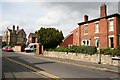
St.Catherines Road
Suburban street of Victorian villas in Lincoln
Image: © Richard Croft
Taken: 9 Sep 2007
0.06 miles
10
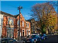
Colegrave Street and an old-style telegraph pole, Lincoln
A residential street in the St Katherines area of Lincoln. St Katherines Church is vaguely visible behind the tree on the right. Visible in the foreground is an unusual telegraph pole (installed 1957), featuring the old-style cross-arms.
Image: © Oliver Mills
Taken: 4 Nov 2020
0.06 miles