IMAGES TAKEN NEAR TO
The Paddock, Peel Street, LINCOLN, LN5 8BX
Introduction
This page details the photographs taken nearby to The Paddock, Peel Street, LN5 8BX by members of the Geograph project.
The Geograph project started in 2005 with the aim of publishing, organising and preserving representative images for every square kilometre of Great Britain, Ireland and the Isle of Man.

There are currently over 7.5m images from over14,400 individuals and you can help contribute to the project by visiting https://www.geograph.org.uk
Image Map
Images are licensed for reuse under creativecommons.org/licenses/by-sa/2.0
Notes
- Clicking on the map will re-center to the selected point.
- The higher the marker number, the further away the image location is from the centre of the postcode.
Image Listing (122 Images Found)
Images are licensed for reuse under creativecommons.org/licenses/by-sa/2.0
Image
Details
Distance
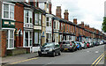
1
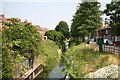
Boultham Avenue
Drain between Boultham Avenue (right) and the rear of houses on Vernon Street (left)
Image: © Richard Croft
Taken: 9 Jun 2006
0.02 miles
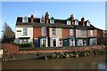
2
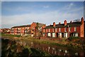
River front properties
A mix of old and new properties with River Witham frontage
Image: © Richard Croft
Taken: 1 Jan 2007
0.06 miles
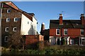
3
Houses overlooking the River Witham at Dixon Street, Lincoln
Image: © Ian S
Taken: 18 Jul 2018
0.07 miles
4
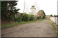
Embankment
Embankment behind Peel Street, accessed through the gateway at 76 High Street http://www.geograph.org.uk/photo/3301006 where the Lincoln avoiding line passed from 1882 to 1982
Image: © Richard Croft
Taken: 12 Jan 2013
0.07 miles
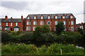
5
Boultham Avenue, Lincoln
Late Victorian terraces facing Great Gowts Drain (Image]).
Image: © Stephen Richards
Taken: 15 Jun 2015
0.07 miles
6
Eastern Terrace
River Witham waterfront properties
Image: © Richard Croft
Taken: 1 Jan 2007
0.07 miles
7
View of the mill
Le Tall's Mill http://www.geograph.org.uk/photo/82091 glimpsed between riverside properties from the west bank of the River Witham
Image: © Richard Croft
Taken: 1 Jan 2007
0.07 miles
8
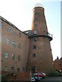
Le Tall's Mill Lincoln
Located just off the High Street in Princess Street. Built late 1840's as a five sail mill. Passed to Henry Le Tall in 1871. Was converted to run under steam power with roller flour mills before being gutted and used as a silo and water tower with Le Tall's name distinctly on the top. Now converted into flats. This huge tower dwarfs the surrounding houses and is the second highest in the country after Moulton Mill.
Image: © Colin Mitchell
Taken: 12 Nov 2005
0.07 miles
10
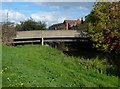
Dixon Street Bridge
Crossing the River Witham in Lincoln.
Image: © Mat Fascione
Taken: 19 Oct 2015
0.08 miles