IMAGES TAKEN NEAR TO
High Street, LINCOLN, LN5 8BQ
Introduction
This page details the photographs taken nearby to High Street, LN5 8BQ by members of the Geograph project.
The Geograph project started in 2005 with the aim of publishing, organising and preserving representative images for every square kilometre of Great Britain, Ireland and the Isle of Man.

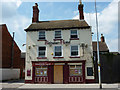
There are currently over 7.5m images from over14,400 individuals and you can help contribute to the project by visiting https://www.geograph.org.uk
Image Map
Images are licensed for reuse under creativecommons.org/licenses/by-sa/2.0
Notes
- Clicking on the map will re-center to the selected point.
- The higher the marker number, the further away the image location is from the centre of the postcode.
Image Listing (137 Images Found)
Images are licensed for reuse under creativecommons.org/licenses/by-sa/2.0
Image
Details
Distance
1
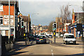
High Street
View along High Street from St.Catherine's
Image: © Richard Croft
Taken: 7 Mar 2012
0.01 miles
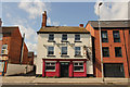
2
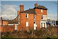
Great Bar shop
Former Post Office and earlier grocers on High Street by Gowt's Bridge at Great Bar
Image: © Richard Croft
Taken: 7 Mar 2012
0.01 miles
3
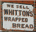
Painted sign
Sign on the former grocers at Great Bar http://www.geograph.org.uk/photo/2839359
Image: © Richard Croft
Taken: 7 Mar 2012
0.01 miles
4
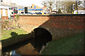
Gowts Bridge
Grade II listed bridge where High Street crosses Sincil Dyke at Great Bar
Image: © Richard Croft
Taken: 7 Mar 2012
0.02 miles
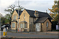
5
The Reindeer Hotel
Historic hostelry on Lincoln High Street, sadly, now closed.
Image: © Richard Croft
Taken: 11 Aug 2012
0.02 miles
6
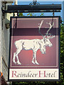
The sign of the Reindeer
Pub sign for the (now closed) Reindeer Hotel http://www.geograph.org.uk/photo/3103645
Image: © Richard Croft
Taken: 11 Aug 2012
0.02 miles
7
Reindeer Hotel
Former Inn on High Street dating back to at least 1720, closed in 2011 http://www.geograph.org.uk/photo/3103645 now residential.
Image: © Richard Croft
Taken: 4 Sep 2019
0.02 miles
8
Old Police House
The old Police House on South Park
Image: © Richard Croft
Taken: 11 Aug 2012
0.03 miles
9
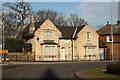
Old Police House
Former Police House at the junction of South Park, High Street and St.Catherine's
Image: © Richard Croft
Taken: 7 Mar 2012
0.03 miles
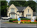
10
The Old Police House, South Park, Lincoln
Built between 1868 and 1877 replacing the South Common Toll Gate House. It was a Police Station until at least 1965 and since 1974 it has been a private residence. (City Fire and Police Station in Church Lane closed in 1967 but continued as a store until around the time Nettleham headquarters were officially opened in November 1981).
Image: © Jo and Steve Turner
Taken: 31 Oct 2022
0.03 miles