IMAGES TAKEN NEAR TO
Kirkby Street, LINCOLN, LN5 7UA
Introduction
This page details the photographs taken nearby to Kirkby Street, LN5 7UA by members of the Geograph project.
The Geograph project started in 2005 with the aim of publishing, organising and preserving representative images for every square kilometre of Great Britain, Ireland and the Isle of Man.

There are currently over 7.5m images from over14,400 individuals and you can help contribute to the project by visiting https://www.geograph.org.uk
Image Map
Images are licensed for reuse under creativecommons.org/licenses/by-sa/2.0
Notes
- Clicking on the map will re-center to the selected point.
- The higher the marker number, the further away the image location is from the centre of the postcode.
Image Listing (135 Images Found)
Images are licensed for reuse under creativecommons.org/licenses/by-sa/2.0
Image
Details
Distance
1
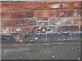
Cut Mark: Lincoln, 31 Thesiger Street
Cut bench mark on the south face of a house at the junction of Thesiger Street with St Andrews Street. See http://www.bench-marks.org.uk/bm72177 for details.
Image: © Brian Westlake
Taken: 14 Dec 2015
0.04 miles
2
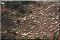
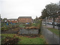
Terraces east of Sincil bank, Lincoln: aerial 2016
Image: © Chris
Taken: 24 Jun 2016
0.07 miles
3
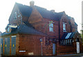
St Andrews Parsonage House, Corner of Cross Street and Thesiger Street
Built as St Andrews Parsonage House, architect William Dymock Pratt (1854–1916), for Rev Walter Wanstall. Planning was approved in February 1887. (Cross street was laid out 1873 to 1895). In WWII there was a public air raid shelter for 50 people here. St Andrew’s Church was demolished in 1968 and the parsonage became a private house. Occupants include; 1894 both Rev Wanstall and Rev Truman are listed here; 1897-1913 Rev Canon J E Truman; 1919 Rev Robert Walker Watt; 1965 George B Barnes. The electricity sub station remains, with a new roof, but the house was demolished about 1990 to make way for 1-16 Vicarage Court.
Image: © Jo and Steve Turner
Taken: Unknown
0.07 miles
4
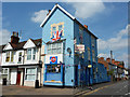
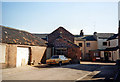
Ripon Street Stores
It would be hard to miss Ripon Street Stores on the corner of Ripon Street and St.Andrew's Street - with Union flags for the Jubilee, Olympics and Paralympics in 2012
Image: © Richard Croft
Taken: 11 Aug 2012
0.09 miles
5
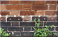
Benchmark on #31 St Andrew's Street, Ripon Street face
Ordnance Survey cut mark benchmark described on the Bench Mark Database at www.bench-marks.org.uk/bm38047
Image: © phil Richards
Taken: 11 Sep 2019
0.09 miles
6
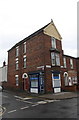
#31 St Andrew's Street at Ripon Street junction
There is an OS benchmark Image about 2.5 feet right of the near corner of the building
Image: © phil Richards
Taken: 11 Sep 2019
0.09 miles
9
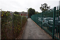
Thesiger Street East
The building with the 'Drugs' sign has gone as has the low building on the left that has been replaced with a row of town houses.
Image: © Jo and Steve Turner
Taken: Unknown
0.10 miles