IMAGES TAKEN NEAR TO
Vernon Street, LINCOLN, LN5 7QU
Introduction
This page details the photographs taken nearby to Vernon Street, LN5 7QU by members of the Geograph project.
The Geograph project started in 2005 with the aim of publishing, organising and preserving representative images for every square kilometre of Great Britain, Ireland and the Isle of Man.

There are currently over 7.5m images from over14,400 individuals and you can help contribute to the project by visiting https://www.geograph.org.uk
Image Map
Images are licensed for reuse under creativecommons.org/licenses/by-sa/2.0
Notes
- Clicking on the map will re-center to the selected point.
- The higher the marker number, the further away the image location is from the centre of the postcode.
Image Listing (142 Images Found)
Images are licensed for reuse under creativecommons.org/licenses/by-sa/2.0
Image
Details
Distance
1
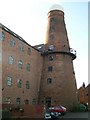
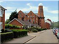
Le Tall's Mill Lincoln
Located just off the High Street in Princess Street. Built late 1840's as a five sail mill. Passed to Henry Le Tall in 1871. Was converted to run under steam power with roller flour mills before being gutted and used as a silo and water tower with Le Tall's name distinctly on the top. Now converted into flats. This huge tower dwarfs the surrounding houses and is the second highest in the country after Moulton Mill.
Image: © Colin Mitchell
Taken: 12 Nov 2005
0.02 miles
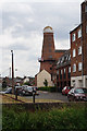
2
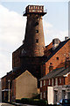
Le Tall's Mill
Before conversion from a water tower to flats.
Image: © Jo and Steve Turner
Taken: Unknown
0.05 miles
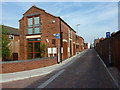
3
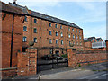
Crown Mill
Vernon Street view of Crown Mill, the Princess Street view is dominated by Le Tall's mill http://www.geograph.org.uk/photo/82091
Image: © Richard Croft
Taken: 22 Sep 2010
0.06 miles
4
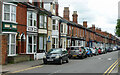
Boultham Avenue, Lincoln
Late Victorian terraces facing Great Gowts Drain (Image]).
Image: © Stephen Richards
Taken: 15 Jun 2015
0.06 miles
5
Princess Street, Lincoln
To the rear is Le Tall's Mill. A serious fire occurred within a building adjoining the mill during 23rd/24th August 1911, which resulted in the death of a fire-fighter and a member of the public. The newspaper account is not entirely accurate as you will find if you read the whole of the page - http://itsaboutlincoln.wordpress.com/2013/04/22/tragedy-on-princess-street/
Image: © Dave Hitchborne
Taken: 1 Jul 2008
0.06 miles
6
Mill Lane
Narrow lane off Lincoln High Street
Image: © Richard Croft
Taken: 22 Sep 2010
0.06 miles
8
Embankment
Embankment behind Peel Street, accessed through the gateway at 76 High Street http://www.geograph.org.uk/photo/3301006 where the Lincoln avoiding line passed from 1882 to 1982
Image: © Richard Croft
Taken: 12 Jan 2013
0.07 miles
9
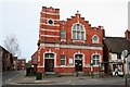
Salvation Army Citadel
On Lower High Street, Lincoln
Image: © Richard Croft
Taken: 3 Jan 2007
0.07 miles
10
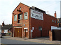
Princess Street Garage
Workshop on Princess Street, formerly the premises of plumbers R.Pratley & Sons Ltd.
Image: © Richard Croft
Taken: 22 Sep 2010
0.07 miles