IMAGES TAKEN NEAR TO
St. Andrews Street, LINCOLN, LN5 7ND
Introduction
This page details the photographs taken nearby to St. Andrews Street, LN5 7ND by members of the Geograph project.
The Geograph project started in 2005 with the aim of publishing, organising and preserving representative images for every square kilometre of Great Britain, Ireland and the Isle of Man.

There are currently over 7.5m images from over14,400 individuals and you can help contribute to the project by visiting https://www.geograph.org.uk
Image Map
Images are licensed for reuse under creativecommons.org/licenses/by-sa/2.0
Notes
- Clicking on the map will re-center to the selected point.
- The higher the marker number, the further away the image location is from the centre of the postcode.
Image Listing (122 Images Found)
Images are licensed for reuse under creativecommons.org/licenses/by-sa/2.0
Image
Details
Distance
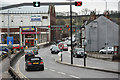
1
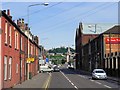
Canwick Road, Lincoln
Looking south along Canwick Road in Lincoln. Lights on the gantry above the road indicate which lanes are open to cars in both directions.
Image: © Graham Robson
Taken: 12 Jul 2023
0.03 miles
2
Dunford Road at the junction of Canwick Road
Image: © David Howard
Taken: 13 Jan 2018
0.03 miles
3
Canwick Road
View south along Canwick Road from Pelham Bridge, the opposite view to http://www.geograph.org.uk/photo/2746191
Image: © Richard Croft
Taken: 31 Dec 2011
0.04 miles
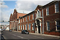
4
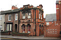
Fambrini & Daniels office
Grade II listed building by William Mortimer in 1889, otherwise known as 85 Canwick Road. Originally the offices of Fambrini & Daniels. Joseph Fambrini was a plasterer in the 1850s, who became a manufacturer of artificial stone and concrete in the 1860s. He built a workshop at 85 Canwick Road in 1878, later developing into the show yard and offices of the company of Fambrini and Daniels. The red brick office building on Canwick Road has many decorative features in brick and terracotta, including the city crest on the north elevation and an 1889 date-stone on the north elevation. From c1913 to at least the 1930s the site was occupied by the Lindum Stone Company
Image: © Richard Croft
Taken: 31 Dec 2011
0.04 miles
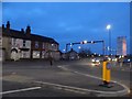
5
Canwick Road
The A15, one of the main routes into Lincoln from the south with a 'tidal' traffic flow system. Here, two lanes in and one out, though this alters to accommodate changes in traffic volume. The opposite view to http://www.geograph.org.uk/photo/2746195
Image: © Richard Croft
Taken: 31 Dec 2011
0.05 miles
6
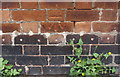
Benchmark on #31 St Andrew's Street, Ripon Street face
Ordnance Survey cut mark benchmark described on the Bench Mark Database at www.bench-marks.org.uk/bm38047
Image: © phil Richards
Taken: 11 Sep 2019
0.06 miles
7
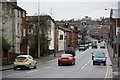
#31 St Andrew's Street at Ripon Street junction
There is an OS benchmark Image about 2.5 feet right of the near corner of the building
Image: © phil Richards
Taken: 11 Sep 2019
0.06 miles
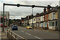
8
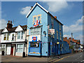
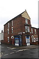
Ripon Street Stores
It would be hard to miss Ripon Street Stores on the corner of Ripon Street and St.Andrew's Street - with Union flags for the Jubilee, Olympics and Paralympics in 2012
Image: © Richard Croft
Taken: 11 Aug 2012
0.06 miles
9
Robey Works
Classical frontage of the former Robey Works on Canwick Road, now Jackson's builders merchants
Image: © Richard Croft
Taken: 1 Nov 2010
0.08 miles