IMAGES TAKEN NEAR TO
Witham Park, Waterside South, LINCOLN, LN5 7JH
Introduction
This page details the photographs taken nearby to Witham Park, Waterside South, LN5 7JH by members of the Geograph project.
The Geograph project started in 2005 with the aim of publishing, organising and preserving representative images for every square kilometre of Great Britain, Ireland and the Isle of Man.

There are currently over 7.5m images from over14,400 individuals and you can help contribute to the project by visiting https://www.geograph.org.uk
Image Map
Images are licensed for reuse under creativecommons.org/licenses/by-sa/2.0
Notes
- Clicking on the map will re-center to the selected point.
- The higher the marker number, the further away the image location is from the centre of the postcode.
Image Listing (85 Images Found)
Images are licensed for reuse under creativecommons.org/licenses/by-sa/2.0
Image
Details
Distance
1
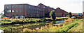
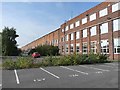
Titanic Works, Lincoln
Former Titanic Works and offices, Waterside South now known as Enterprise House, Witham Park House and Oak House Business Centre. The remaining former works is in three parts. The very long manufacturing bay, a shorter but still long manufacturing bay adjoining the former to the north and an office block inserted at an acute angle along the property line in the northeast. Local folklore suggests the southern bay was the same length as its infamous namesake but in fact the building was over 100ft longer than the liner at about 1,000ft (305m). From the 1946-50 to the 1985-90 OS maps the northern bay is shown almost as long as the southern bay. It was built in 1912 by Wm. Wright and architect Arthur Turner of Oldham for Clayton and Shuttleworth who built crawler tractors. From 1916 to 1919 it turned to aircraft production including Sopwith Camels, Triplane Scouts and Bristol triplanes all tested at Bracebridge Heath. In 1920 Clayton Wagons Ltd. manufactured steam road wagons, railway passenger and freight wagons and railcars here and in Abbey Works. Clayton Wagons made the Dewandre servo that was so successful in 1928 Clayton Dewandre Company was established and they subsequently purchased the Titanic works in 1929 when Clayton Wagons folded. In November 1986 Clayton Dewandre (now part of American Standard Inc) announced that it was closing down its operation over the next eighteen months, with the loss of seven hundred jobs. Up to and including the 1985-90 OS map additional building/s are shown on the west end of the southern bay that have subsequently been removed presumably during refurbishment by Simons of Lincoln in 1992. Subdivided the buildings now contain a number of businesses including Anglian Water Services, Compass FM, Sports Direct Fitness Lincoln City and Lincs FM Group. Fenestration has been considerably altered and other ancillary buildings removed from the site, particularly along Waterside South, presumably as part of the 1992 refurbishment after Dewandre’s closure in 1989.
Image: © Jo and Steve Turner
Taken: Unknown
0.03 miles
2

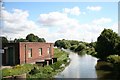
River Witham
View east from Titanic Bridge
Image: © Richard Croft
Taken: 28 Jan 2012
0.03 miles
3
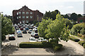
Stamp End
Car-parks for offices at Stamp End
Image: © Richard Croft
Taken: 11 Aug 2010
0.03 miles
4
Stamp End
River Witham and offices from the viewing platform http://www.geograph.org.uk/photo/933959
Image: © Richard Croft
Taken: 23 Aug 2008
0.03 miles
5
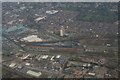
Clayton and Shuttleworth Titanic Works: aerial
The Factory where the Sopwith Camels were built.
The "Titanic" building, originally an aircraft factory, now sub-divided between a number of commercial enterprises, is supposedly so named because it was as large as SS Titanic.
Image: © Chris
Taken: 3 Mar 2013
0.04 miles
6
River Witham
Looking east from Titanic Bridge
Image: © Richard Croft
Taken: 23 Aug 2008
0.04 miles
7
The "Titanic" building, Lincoln
The "Titanic" building, originally an aircraft factory, now sub-divided between a number of commercial enterprises, is supposedly so named because it was as large as SS Titanic. The Titanic building starts just beyond the red car, the nearer building is separate and of much more recent construction.
Image: © Oliver Dixon
Taken: 11 Oct 2012
0.04 miles
8
Titanic Bridge
Former lifting bridge of 1912 at Stamp End, greatly altered in 1990 to carry light traffic to Witham Park, established in the old Titanic Works http://www.geograph.org.uk/photo/2448713
Image: © Richard Croft
Taken: 31 Dec 2011
0.05 miles
9

Titanic Bridge
Former lifting bridge of 1912 at Stamp End, greatly altered in 1990 to carry light traffic to Witham Park, established in the old Titanic Works http://www.geograph.org.uk/photo/2448713
Image: © Richard Croft
Taken: 31 Dec 2011
0.05 miles
10
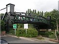
Lifting Bridge over River Witham
This former lifting bridge was constructed in 1912 as a railway bridge to carry the railway line from the Titanic engineering works to the former G.N.R Lincolnshire loop line. It was converted to carry road traffic in 1990. The bridge is named Titanic bridge.
Image: © Betty Longbottom
Taken: 4 Sep 2009
0.05 miles