IMAGES TAKEN NEAR TO
Waterside South, LINCOLN, LN5 7FD
Introduction
This page details the photographs taken nearby to Waterside South, LN5 7FD by members of the Geograph project.
The Geograph project started in 2005 with the aim of publishing, organising and preserving representative images for every square kilometre of Great Britain, Ireland and the Isle of Man.

There are currently over 7.5m images from over14,400 individuals and you can help contribute to the project by visiting https://www.geograph.org.uk
Image Map
Images are licensed for reuse under creativecommons.org/licenses/by-sa/2.0
Notes
- Clicking on the map will re-center to the selected point.
- The higher the marker number, the further away the image location is from the centre of the postcode.
Image Listing (672 Images Found)
Images are licensed for reuse under creativecommons.org/licenses/by-sa/2.0
Image
Details
Distance
1
Pelham Street
Deserted sliproad to the side of Pelham Bridge, Lincoln. This was a major thoroughfare before Pelham Bridge was built, crossing the railway close to Durham Ox junction. It was an unweildy method of operation with at least two crossing keepers having to manually close the gates for trains to cross.
Image: © Donnylad
Taken: 2 Jun 2007
0.03 miles
2

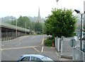
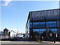
Pelham Street
Siemens new office block off Pelham Street Lincoln from the steps up to the bridge.
Image: © Jo and Steve Turner
Taken: 23 Oct 2011
0.04 miles
3
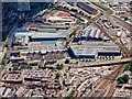
Pelham Works
This is the site of Lincolns largest employers. Currently owned by Siemens it has been known by many names including Alstom, European Gas Turbines and Ruston & Hornsby to name a few. They are one of the worlds largest Industrial Gas Turbine manufacturers.
Image: © Bob Danylec
Taken: 11 Nov 2005
0.05 miles
4
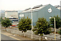
RGT Works, Pelham Street, Lincoln
Former Ruston Gas Turbines works now Siemens Industrial Turbomachinery Ltd. offices bays 8 and 9 underwent a substantial £5m refurbishment, along with reconfiguration of the associated landscaping and car park, following planning approval in March 2011 and the official opening in January 2012. Industrial buildings appear to be shown here between the 1905-07 and 1906-08 OS maps. The existing Malthouse was used by Ruston’s as a pattern store by 1908 having been available for let from 1903. It is likely the bays were built between 1908 and 1921 based on map evidence. They are seen on 1926 aerial photographs. (Ruston Gas Turbines (RGT) name started to be used to market the turbines in 1969. They changed name to European Gas Turbines in October 1991, Alstom Gas Turbines in June 1998, ABB Alstom Power UK in September 1999, Alstom Power UK in October 2000 and Alstom Power UK Holdings in March 2002 that was unlimited in 2004 and stopped trading in 2006 having become part of Siemens (UK) in April 2003. Siemens lease the site from St Modwen.) See Image for new offices.
Image: © Jo and Steve Turner
Taken: 20 Aug 1989
0.05 miles
5
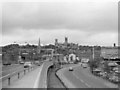
Lincoln, 1985
The view of Lincoln from the bridge across the railway towards the Cathedral in the spring of 1985.
Image: © Rob Newman
Taken: 25 May 1985
0.06 miles
6
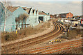
Railway view from Pelham Bridge
View east where the line from Central Station branches left for Market Rasen and right for Sleaford
Image: © Richard Croft
Taken: 25 Feb 2012
0.06 miles
7
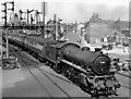
Southbound express leaving Lincoln Central Station
View NW, towards Lincoln Central station and the main lines to Gainsborough and Doncaster (ex-Great Northern & Great Eastern Joint), Retford and Sheffield (ex-Great Central). This Pelham Street Crossing in the middle of the City was one of the busiest level-crossings - hand-operated gates worked by four crossing-keepers - surviving until a road bridge was eventually built in 1961. LNE B1 4-6-0 No. 61326 was shunting stock.
Image: © Ben Brooksbank
Taken: 21 May 1956
0.07 miles
9
Siemens
Entrance to the Siemens complex in Lincoln
Image: © Debbie J
Taken: 26 Sep 2015
0.07 miles
10
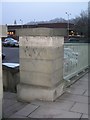
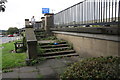
Steps at the north end of Pelham Bridge, Lincoln
The post carried a cut bench mark on the right-hand face. See https://www.geograph.org.uk/photo/6276319 for a closer view and https://www.bench-marks.org.uk/bm25910 for details of the mark. The area of the car park shown and the building beyond have all been redeveloped to form a new bus station and multi-storey car park so the steps and post no longer exist.
Image: © Brian Westlake
Taken: 21 Dec 2007
0.07 miles