IMAGES TAKEN NEAR TO
Barkers Court, Melville Street, LINCOLN, LN5 7BW
Introduction
This page details the photographs taken nearby to Barkers Court, Melville Street, LN5 7BW by members of the Geograph project.
The Geograph project started in 2005 with the aim of publishing, organising and preserving representative images for every square kilometre of Great Britain, Ireland and the Isle of Man.

There are currently over 7.5m images from over14,400 individuals and you can help contribute to the project by visiting https://www.geograph.org.uk
Image Map
Images are licensed for reuse under creativecommons.org/licenses/by-sa/2.0
Notes
- Clicking on the map will re-center to the selected point.
- The higher the marker number, the further away the image location is from the centre of the postcode.
Image Listing (1324 Images Found)
Images are licensed for reuse under creativecommons.org/licenses/by-sa/2.0
Image
Details
Distance
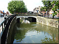
1
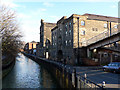
Waterside South
Looking east from Thorn Bridge
Image: © Ian Carrington
Taken: 20 Jan 2006
0.00 miles
2
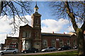
Wesleyan Day School
The New Wesleyan Day School by architects Bellamy & Hardy opened 6th October 1859, long closed and awaiting redevelopment with housing behind.
Image: © Richard Croft
Taken: 4 Mar 2006
0.00 miles
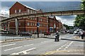
3
Broadgate (A15), Lincoln
The pedestrian footbridge links Waterside South over the A15.
Image: © Dave Hitchborne
Taken: 11 Jul 2008
0.00 miles
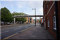
4
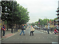
Pedestrian crossing on Broadgate
Looking south. The footbridge can be seen across the road.
Image: © John Firth
Taken: 6 Jun 2011
0.01 miles
5
Thorn Bridge
View from Waterside South to Thorn Bridge over the River Witham
Image: © Richard Croft
Taken: 11 Aug 2012
0.01 miles
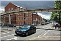
6
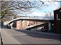
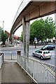
Ramped footbridge on Melville Street
View from a service road near the River Witham.
Image: © Ian Paterson
Taken: 4 Apr 2009
0.01 miles
8
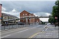
Broadgate (A15), Lincoln
Junction of Broadgate and Thorngate - This road gets quite busy. There is a pelican crossing here as well as the footbridge. Ahead is the flyover, which was built to replace the railway level crossing. The railway and road traffic have never run smoothly together and when there were two stations the trains often brought the roads to a standstill. There are plans to better the situation even further.
Image: © Dave Hitchborne
Taken: 11 Jul 2008
0.01 miles
9
Footbridge on the A15, Lincoln
The pedestrian footbridge joins Waterside South at the east and west of the A15.
Image: © Dave Hitchborne
Taken: 11 Jul 2008
0.01 miles
10
A15, Lincoln
Through the pedestrian footbridge can be seen Nacro - Lincolnshire Dispersed Supported Housing helps homeless people to access good supported housing and stay out of trouble. The service is designed to support offenders, those at risk of offending and those with mental health problems.
Image: © Dave Hitchborne
Taken: 11 Jul 2008
0.01 miles