IMAGES TAKEN NEAR TO
St. Mark Street, LINCOLN, LN5 7BA
Introduction
This page details the photographs taken nearby to St. Mark Street, LN5 7BA by members of the Geograph project.
The Geograph project started in 2005 with the aim of publishing, organising and preserving representative images for every square kilometre of Great Britain, Ireland and the Isle of Man.

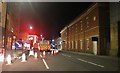
There are currently over 7.5m images from over14,400 individuals and you can help contribute to the project by visiting https://www.geograph.org.uk
Image Map
Images are licensed for reuse under creativecommons.org/licenses/by-sa/2.0
Notes
- Clicking on the map will re-center to the selected point.
- The higher the marker number, the further away the image location is from the centre of the postcode.
Image Listing (1220 Images Found)
Images are licensed for reuse under creativecommons.org/licenses/by-sa/2.0
Image
Details
Distance
1
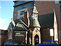
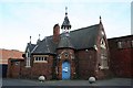
St Marks Church Hall, St Marks Street, Lincoln
Grade II Listed former church hall. Built as St Marks Parochial School 1875, architect W Watkins. In the 1901 City Directory it is described as 'St. Mark's Day School-Miss Jackson. head-mistress'. In 1913 it is St Marks Sunday School. 1970 to date the RSPCA Centre, it was refurbish around 2010. St Marks Street was St Marks Lane from about 1685 to about 1900. The section near the High Street was St Marks Place/Square until widening in February 1935.
Image: © Jo and Steve Turner
Taken: 7 Feb 2014
0.01 miles
2

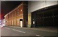
A sad building relationship on St Marks Road, Lincoln
In the foreground is the St Marks Church Hall; Grade II Listed and currently an RSPCA shop. Unceremoniously dumped alongside it in 2013 is St Mark's Apartments, which is discourteous enough to swallow the East wall of the church. Interestingly, the building was built almost entirely out of modular elements, including pre-fabricated room pods which are dropped into place with a crane... but still, it is so rude!
Image: © Oliver Mills
Taken: 18 Jan 2020
0.01 miles
4
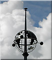
Lincoln's globe (well art above Debenham's)
Image: © Steve Fareham
Taken: 12 May 2014
0.02 miles
5
Roadworks on Rope Walk, Lincoln
A lot of the centre of Lincoln is being dug up at the moment, and there are a few diversions in place sending everyone round the houses.
Image: © David Howard
Taken: 6 Aug 2019
0.03 miles
6
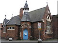
St.Mark's Hall
Former church hall for St.Mark's, now RSPCA offices, on St.Mark's Street
Image: © Richard Croft
Taken: 1 Jan 2007
0.03 miles
7

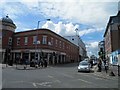
The Treaty of Commerce, High St
Opened in 1862 and one of the last independent pubs in the High Street. Now surrounded by more modern businesses.
Image: © Robert Eva
Taken: 15 Jan 2020
0.03 miles
9
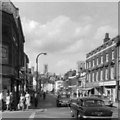
High Street, Lincoln
From the box junction at the corners of St Mark Street and Tentercroft Street. I'm informed that the Pen Shop still has the same angled façade, and is now a newsagents. The Godfrey Jones building now houses a Chinese supermarket, a Stringers store and a Mind charity shop. The tower appears to be that of St. Mary-Le-Wigford Church.
Image: © Gerald England
Taken: Unknown
0.03 miles