IMAGES TAKEN NEAR TO
Sutton Road, LINCOLN, LN5 0RD
Introduction
This page details the photographs taken nearby to Sutton Road, LN5 0RD by members of the Geograph project.
The Geograph project started in 2005 with the aim of publishing, organising and preserving representative images for every square kilometre of Great Britain, Ireland and the Isle of Man.

There are currently over 7.5m images from over14,400 individuals and you can help contribute to the project by visiting https://www.geograph.org.uk
Image Map
Images are licensed for reuse under creativecommons.org/licenses/by-sa/2.0
Notes
- Clicking on the map will re-center to the selected point.
- The higher the marker number, the further away the image location is from the centre of the postcode.
Image Listing (3 Images Found)
Images are licensed for reuse under creativecommons.org/licenses/by-sa/2.0
Image
Details
Distance
1
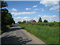
Former council houses, Beckingham
As is often the case in this part of Lincolnshire council houses were built at some distance from the village of which they were supposedly part.
Image: © Jonathan Thacker
Taken: 12 Jun 2010
0.02 miles
2
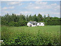
Decaying shed, Beckingham playing field
Image: © Jonathan Thacker
Taken: 12 Jun 2010
0.24 miles