IMAGES TAKEN NEAR TO
Soggin Lane, LINCOLN, LN5 0QH
Introduction
This page details the photographs taken nearby to Soggin Lane, LN5 0QH by members of the Geograph project.
The Geograph project started in 2005 with the aim of publishing, organising and preserving representative images for every square kilometre of Great Britain, Ireland and the Isle of Man.

There are currently over 7.5m images from over14,400 individuals and you can help contribute to the project by visiting https://www.geograph.org.uk
Image Map
Images are licensed for reuse under creativecommons.org/licenses/by-sa/2.0
Notes
- Clicking on the map will re-center to the selected point.
- The higher the marker number, the further away the image location is from the centre of the postcode.
Image Listing (7 Images Found)
Images are licensed for reuse under creativecommons.org/licenses/by-sa/2.0
Image
Details
Distance
1
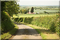
Hilltop view
View down the lane from Hilltop Farm with the Trent Valley beypond
Image: © Richard Croft
Taken: 14 Jun 2012
0.10 miles
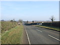
5
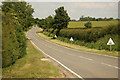
Pottergate Road
Road scene on Welbourn Heath
Image: © Richard Croft
Taken: 14 Jun 2012
0.17 miles
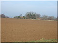
6
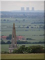
Towers of power
View from the viewpoint over the steeple of St Chad's Church, Welbourn Image High Marnham Power Station Image is in the distance.
Image: © Ian Paterson
Taken: 23 Jun 2012
0.22 miles
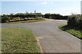
7
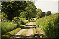
Hilltop Farm Lane
Narrow lane to Welbourn from Welbourn Heath
Image: © Richard Croft
Taken: 14 Jun 2012
0.23 miles