IMAGES TAKEN NEAR TO
Crow Lane, LINCOLN, LN5 0PJ
Introduction
This page details the photographs taken nearby to Crow Lane, LN5 0PJ by members of the Geograph project.
The Geograph project started in 2005 with the aim of publishing, organising and preserving representative images for every square kilometre of Great Britain, Ireland and the Isle of Man.

There are currently over 7.5m images from over14,400 individuals and you can help contribute to the project by visiting https://www.geograph.org.uk
Image Map
Images are licensed for reuse under creativecommons.org/licenses/by-sa/2.0
Notes
- Clicking on the map will re-center to the selected point.
- The higher the marker number, the further away the image location is from the centre of the postcode.
Image Listing (20 Images Found)
Images are licensed for reuse under creativecommons.org/licenses/by-sa/2.0
Image
Details
Distance
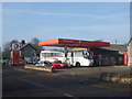
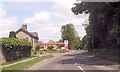
1

Rebuilt wall, Crow Lane
This wall had become very dilapidated and unsafe before rebuilding.
Image: © Jonathan Thacker
Taken: 12 Dec 2013
0.03 miles
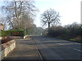
3
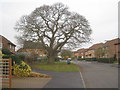
Preserved tree, Waterloo Paddock
Gives a little character to an otherwise ordinary suburban street.
Image: © Jonathan Thacker
Taken: 12 Dec 2013
0.07 miles
4
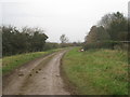
Lemon Wong Lane
Wong is a local word meaning field. But why Lemon? A family name?
Image: © Jonathan Thacker
Taken: 12 Dec 2013
0.07 miles
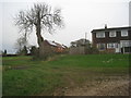
5
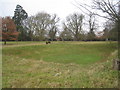
Field by the Old Hall
The hollow in the foreground is marked on maps as a pond but at present is dry.
Image: © Jonathan Thacker
Taken: 12 Dec 2013
0.09 miles
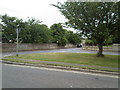
9
The upper end of Lemon Wong Lane
The houses are in North Road.
Image: © Jonathan Thacker
Taken: 16 Dec 2013
0.13 miles
10
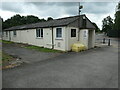
Building at Lincoln Road Industrial Estate, Leadenham
This building [and others behind] are shown on the OS map surveyed in 1960 and look to date from the Second World War.
Image: © Christine Johnstone
Taken: 3 Jul 2022
0.14 miles