IMAGES TAKEN NEAR TO
Hall Orchard Lane, LINCOLN, LN5 0NG
Introduction
This page details the photographs taken nearby to Hall Orchard Lane, LN5 0NG by members of the Geograph project.
The Geograph project started in 2005 with the aim of publishing, organising and preserving representative images for every square kilometre of Great Britain, Ireland and the Isle of Man.

There are currently over 7.5m images from over14,400 individuals and you can help contribute to the project by visiting https://www.geograph.org.uk
Image Map
Images are licensed for reuse under creativecommons.org/licenses/by-sa/2.0
Notes
- Clicking on the map will re-center to the selected point.
- The higher the marker number, the further away the image location is from the centre of the postcode.
Image Listing (50 Images Found)
Images are licensed for reuse under creativecommons.org/licenses/by-sa/2.0
Image
Details
Distance

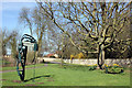
2
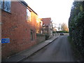
Little Lane, Welbourn
A short street of stone and brick built cottages.
Image: © Jonathan Thacker
Taken: 18 Mar 2011
0.13 miles
3
Castle Hill ringwork Beck Street Welbourn
A Scheduled Ancient Monument; ringworks are medieval fortifications built and occupied from the late Anglo-Saxon period to the later 12th century. They are rare nationally with only 200 recorded examples. Referred to in a document of 1158 as being walled in stone, by 1374 the site was said to be waste and entirely without buildings. A survey of 1288 provides a picture of this manorial estate. There was a walled court surmounted by a small tower and with a ditch. In the court was a hall with two chambers, a kitchen, a brew house, a granary, a stable, an ox house, a cow shed, a sheep fold, trees and garden. A geophysical survey carried out in 1999 recorded the remains of a large tower residence, buttressed and built in limestone, on the west side of the site.
Image: © Jo and Steve Turner
Taken: 24 Mar 2017
0.13 miles
4
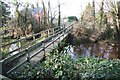
Welbourn Castle Moat
Footbridge over the moat at Castle Hill
Image: © Richard Croft
Taken: 22 Nov 2008
0.13 miles
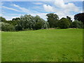
5
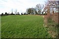
Castle Hill
Earthworks of a ringwork castle, thought to have been built by Anglo-Norman baron Elias de Rabayn in about 1270, a survey of 1288 described extensive stone buildings and a prosperous estate. A scheduled ancient monument owned and maintained as a village amenity space by Welbourn Parish Council http://parishes.lincolnshire.gov.uk/Welbourn/section.asp?catId=12316
Image: © Richard Croft
Taken: 22 Nov 2008
0.13 miles
6
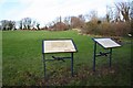
Castle Hill
Interpretation boards at Welbourn Castle Hill http://www.geograph.org.uk/photo/1065193
Image: © Richard Croft
Taken: 22 Nov 2008
0.13 miles
7
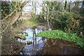
Welbourn Castle Moat
Overgrown moat at Castle Hill
Image: © Richard Croft
Taken: 22 Nov 2008
0.13 miles
8
Castle Hill, Welbourn
A medieval ringwork which enclosed the manor of Northalle https://historicengland.org.uk/listing/the-list/list-entry/1020436?section=official-list-entry
Image: © Jonathan Thacker
Taken: 13 Aug 2023
0.14 miles
9
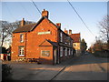
The Joiners Arms, Welbourn
Local limestone was the usual building material until the coming of the railway. The Joiner's Arms is one of the older brick buildings in what is now a predominantly brick built village.
Image: © Jonathan Thacker
Taken: 18 Mar 2011
0.15 miles
10
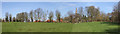
Bell Tree Green, Welbourn
Bell Tree Green is the likely site of Welbourn’s medieval weekly market and annual Fair to celebrate St. Chad.
Image: © Jo and Steve Turner
Taken: 24 Mar 2017
0.16 miles