IMAGES TAKEN NEAR TO
Navenby, LINCOLN, LN5 0LW
Introduction
This page details the photographs taken nearby to LN5 0LW by members of the Geograph project.
The Geograph project started in 2005 with the aim of publishing, organising and preserving representative images for every square kilometre of Great Britain, Ireland and the Isle of Man.

There are currently over 7.5m images from over14,400 individuals and you can help contribute to the project by visiting https://www.geograph.org.uk
Image Map
Images are licensed for reuse under creativecommons.org/licenses/by-sa/2.0
Notes
- Clicking on the map will re-center to the selected point.
- The higher the marker number, the further away the image location is from the centre of the postcode.
Image Listing (11 Images Found)
Images are licensed for reuse under creativecommons.org/licenses/by-sa/2.0
Image
Details
Distance
1
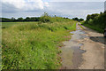
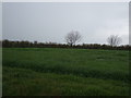
Parson Lane, Skinnand
The one and only house at Skinnand is amongst the trees in the distance.
Image: © Kate Jewell
Taken: 20 Jun 2007
0.06 miles
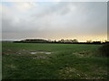
8
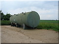
Tank on Hard Standing area at foot of Parson Lane
Image: © Ian Paterson
Taken: 13 Jun 2007
0.22 miles
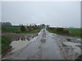
10
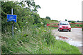
The end of the road
Parson Lane at Skinnand.
Image: © Kate Jewell
Taken: 20 Jun 2007
0.24 miles