IMAGES TAKEN NEAR TO
Castle Lane, LINCOLN, LN5 0LF
Introduction
This page details the photographs taken nearby to Castle Lane, LN5 0LF by members of the Geograph project.
The Geograph project started in 2005 with the aim of publishing, organising and preserving representative images for every square kilometre of Great Britain, Ireland and the Isle of Man.

There are currently over 7.5m images from over14,400 individuals and you can help contribute to the project by visiting https://www.geograph.org.uk
Image Map
Images are licensed for reuse under creativecommons.org/licenses/by-sa/2.0
Notes
- Clicking on the map will re-center to the selected point.
- The higher the marker number, the further away the image location is from the centre of the postcode.
Image Listing (40 Images Found)
Images are licensed for reuse under creativecommons.org/licenses/by-sa/2.0
Image
Details
Distance
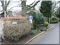
1
Boothby Graffoe - houses at top of Castle Lane
For an alternative view, please see Image
Image: © Dave Bevis
Taken: 22 Aug 2012
0.01 miles

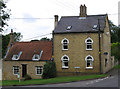
4
Boothby Graffoe - brick cottages on Main Street
Image: © Dave Bevis
Taken: 22 Aug 2012
0.02 miles
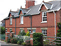
5

Boothby Graffoe - The Pinfold on Main Street
Image: © Dave Bevis
Taken: 22 Aug 2012
0.04 miles
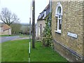
6
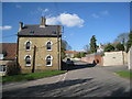
The junction of Main Street and Castle Lane, Boothby Graffoe
The yellow brick building in the centre of the picture shows that by the late nineteenth century it was cheaper to bring brick from some distance away than to use locally quarried stone.
Image: © Jonathan Thacker
Taken: 18 Mar 2011
0.04 miles
7

Snowdrops and Aconites
At Manor Farm, Boothby Graffoe
Image: © Richard Croft
Taken: 4 Feb 2007
0.05 miles