IMAGES TAKEN NEAR TO
Cornelius Close, LINCOLN, LN5 0FS
Introduction
This page details the photographs taken nearby to Cornelius Close, LN5 0FS by members of the Geograph project.
The Geograph project started in 2005 with the aim of publishing, organising and preserving representative images for every square kilometre of Great Britain, Ireland and the Isle of Man.

There are currently over 7.5m images from over14,400 individuals and you can help contribute to the project by visiting https://www.geograph.org.uk
Image Map
Images are licensed for reuse under creativecommons.org/licenses/by-sa/2.0
Notes
- Clicking on the map will re-center to the selected point.
- The higher the marker number, the further away the image location is from the centre of the postcode.
Image Listing (8 Images Found)
Images are licensed for reuse under creativecommons.org/licenses/by-sa/2.0
Image
Details
Distance
1
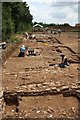
Roman Navenby
Archaeological dig beside High Dike / Ermine Street at Navenby. A Roman Station on Ermine Street, about mid-way between Lincoln and Ancaster
Image: © Richard Croft
Taken: 4 Jul 2009
0.03 miles
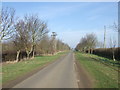
2
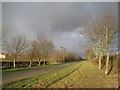
High Dyke at Navenby
Navenby has expanded greatly in recent years as witnessed by the new housing just visible on the left.
Image: © Jonathan Thacker
Taken: 9 Dec 2011
0.03 miles
3
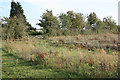
Roman Station site
Site of the recently excavated http://www.geograph.org.uk/photo/1385935 Roman Station by High Dike / Ermine Street at Navenby
Image: © Richard Croft
Taken: 24 Oct 2011
0.07 miles
4
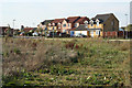
Headland Way
New houses near Ermine Street at Navenby
Image: © Richard Croft
Taken: 24 Oct 2011
0.08 miles
6
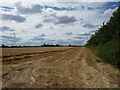
Part harvested field of barley, Navenby
Image: © Jonathan Thacker
Taken: 21 Jul 2024
0.13 miles
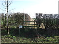
8

Short path
The sign warns that the footpath only runs for the length of one field and then stops.
Image: © Jonathan Thacker
Taken: 9 Dec 2011
0.15 miles