IMAGES TAKEN NEAR TO
Mill Rise, LINCOLN, LN5 0DU
Introduction
This page details the photographs taken nearby to Mill Rise, LN5 0DU by members of the Geograph project.
The Geograph project started in 2005 with the aim of publishing, organising and preserving representative images for every square kilometre of Great Britain, Ireland and the Isle of Man.

There are currently over 7.5m images from over14,400 individuals and you can help contribute to the project by visiting https://www.geograph.org.uk
Image Map
Images are licensed for reuse under creativecommons.org/licenses/by-sa/2.0
Notes
- Clicking on the map will re-center to the selected point.
- The higher the marker number, the further away the image location is from the centre of the postcode.
Image Listing (114 Images Found)
Images are licensed for reuse under creativecommons.org/licenses/by-sa/2.0
Image
Details
Distance
1
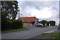
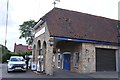
Filling station
A filling station, one of the few on the route of the A607.
See also Image
Image: © Bob Harvey
Taken: 5 Oct 2019
0.05 miles
2
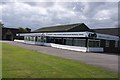
Lawnmower shop
Curiously closed on a Saturday, which seems odd to me. This is part of the complex including the garage and warehouses.
It was once a car showroom, and dates from the late 60s or early 70s.
Image: © Bob Harvey
Taken: 5 Oct 2019
0.05 miles
3
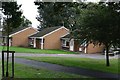
Retirement bungalows
Homes in Cumberland Avenue
Image: © Bob Harvey
Taken: 5 Oct 2019
0.06 miles
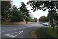
6
Filling station
This filling station shuts on Saturday afternoon and does not re-open until Monday. But it is otherwise very convenient, as it is NOT self-service.
See also Image
Image: © Bob Harvey
Taken: 5 Oct 2019
0.06 miles
7
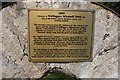
Wellingore Windmill Field - dedicatory plaque
The plaque reads
"2009
Welcome to Wellingore Windmill Field, the site of the parish's former limestone quarry and working windmill.
This structure commemorates the fundamental roles played by the quarry and the windmill in Wellingore's industrial and cultural history. It also introduces a new role for this historic site. The millstone was located at an old mill nearby and the supporting limestone blocks come from the quarry at Metheringham.
The original 18th century windmill was a two storey building with five more floors added in 1854. It was a working mill until the late 1930s and lost its sails during WWII when it was considered too much of a landmark for the Luftwaffe. The quarry mined stone mainly used in building and road repair. It was closed, filled in and grassed over in the mid 1960s.
The field belongs to the parish and has been transformed into both a recreational amenity and a habitat in which the local wildlife can thrive. The Parish Council are most grateful for the generous financial donations from outside agencies and the hard work given freely by parish residents, without which this project would not have been possible."
Image: © Bob Harvey
Taken: 5 Oct 2019
0.06 miles
8
Wellingore Village Cross
Only the base and lower shaft of the ancient Wellingore village cross of c1500 which formerly stood at the west end of Main Street
Image: © Richard Croft
Taken: 9 May 2006
0.06 miles
9
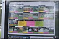
Estate Standards
Rules of the estate on the notice board Image
Image: © Bob Harvey
Taken: 5 Oct 2019
0.06 miles
10
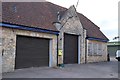
Workshop
The vehicle workshop behind Image
The tall shutter suggests light commercials can be worked on here, as well as cars.
Note the defibrillator on the pier between the rollershutters.
Image: © Bob Harvey
Taken: 5 Oct 2019
0.07 miles