IMAGES TAKEN NEAR TO
Pottergate Road, LINCOLN, LN5 0DP
Introduction
This page details the photographs taken nearby to Pottergate Road, LN5 0DP by members of the Geograph project.
The Geograph project started in 2005 with the aim of publishing, organising and preserving representative images for every square kilometre of Great Britain, Ireland and the Isle of Man.

There are currently over 7.5m images from over14,400 individuals and you can help contribute to the project by visiting https://www.geograph.org.uk
Image Map
Images are licensed for reuse under creativecommons.org/licenses/by-sa/2.0
Notes
- Clicking on the map will re-center to the selected point.
- The higher the marker number, the further away the image location is from the centre of the postcode.
Image Listing (5 Images Found)
Images are licensed for reuse under creativecommons.org/licenses/by-sa/2.0
Image
Details
Distance
1
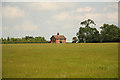
Heath Farm
Farmhouse and a field of barley on Welbourn Heath
Image: © Richard Croft
Taken: 14 Jun 2012
0.09 miles
2
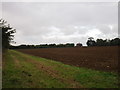
Ploughed field near Heath Farm, Wellingore
Image: © Jonathan Thacker
Taken: 20 Sep 2016
0.14 miles
3
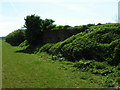
Wartime remains at former RAF Wellingore
Image: © Linda Mellor
Taken: 15 May 2004
0.15 miles
4
ROC Post in the middle of a Second World War "E pen"
Accessed with the kind permission of the landowner
Image: © Adrian S Pye
Taken: 17 Sep 2019
0.21 miles
5
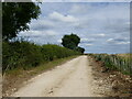
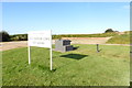
New access to Heath Farm, Wellingore
A hedgerow has been planted on the right.
Image: © Jonathan Thacker
Taken: 21 Jul 2024
0.22 miles