IMAGES TAKEN NEAR TO
Brauncewell, LINCOLN, LN5 0DH
Introduction
This page details the photographs taken nearby to LN5 0DH by members of the Geograph project.
The Geograph project started in 2005 with the aim of publishing, organising and preserving representative images for every square kilometre of Great Britain, Ireland and the Isle of Man.

There are currently over 7.5m images from over14,400 individuals and you can help contribute to the project by visiting https://www.geograph.org.uk
Image Map
Images are licensed for reuse under creativecommons.org/licenses/by-sa/2.0
Notes
- Clicking on the map will re-center to the selected point.
- The higher the marker number, the further away the image location is from the centre of the postcode.
Image Listing (9 Images Found)
Images are licensed for reuse under creativecommons.org/licenses/by-sa/2.0
Image
Details
Distance
1
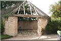
Gin house
No, not a hostelry. It's a "horse engine house". It's function is described by Ian Paterson in connection with an earlier photograph. Now you know where the Lincoln band "Gin House" got its name. It used to feature on a trail of old agricultural buildings promoted by the local council, who generously supplied me with an out-of-print booklet giving details.
Image: © Chris
Taken: 24 Jul 2011
0.05 miles
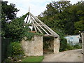
2
Brauncewell Horse Gin
Possibly used for crushing bone to make fertilizer.
Image: © J.Hannan-Briggs
Taken: 10 Mar 2013
0.05 miles
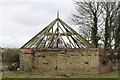
3
Brauncewell Horse Gin
This building was once used as a true horse-powered "engine", as horses were used to turn a central shaft in the circular structure in order to transfer power to carry out some agricultural activity. In this case the activity was likely to have been bone-crushing for fertilisers. The original layout comprised piers for supporting the roof rather than solid wall.
Image: © Ian Paterson
Taken: 13 Sep 2007
0.05 miles
4
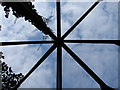
Roof of the Horse Gin
Looking directly upwards (So what direction was I facing?!) into the roof beams of the Brauncewell Horse Gin. Sadly no longer thatched as it once was, but you get the idea. See Image for more information.
Image: © Ian Paterson
Taken: 13 Sep 2007
0.06 miles
5
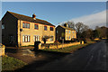
Grange Farm Cottages
Cottages in Brauncewell
Image: © Richard Croft
Taken: 16 Jan 2014
0.07 miles
6
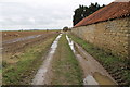
Track and Footpath at Grange Farm
It runs towards Temple Bruer.
Image: © J.Hannan-Briggs
Taken: 10 Mar 2013
0.09 miles
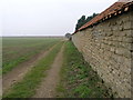
7
Brauncewell
Leaving Brauncewell at the footpath junction with the road
Image: © Richard Croft
Taken: 16 Jan 2014
0.18 miles
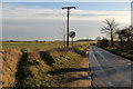
8
Footpath to Temple Bruer
This footpath links Brauncewell with Temple Bruer to the north.
Image: © Michael Patterson
Taken: 30 Mar 2007
0.19 miles
