IMAGES TAKEN NEAR TO
The Heath, LINCOLN, LN5 0BX
Introduction
This page details the photographs taken nearby to The Heath, LN5 0BX by members of the Geograph project.
The Geograph project started in 2005 with the aim of publishing, organising and preserving representative images for every square kilometre of Great Britain, Ireland and the Isle of Man.

There are currently over 7.5m images from over14,400 individuals and you can help contribute to the project by visiting https://www.geograph.org.uk
Image Map
Images are licensed for reuse under creativecommons.org/licenses/by-sa/2.0
Notes
- Clicking on the map will re-center to the selected point.
- The higher the marker number, the further away the image location is from the centre of the postcode.
Image Listing (2 Images Found)
Images are licensed for reuse under creativecommons.org/licenses/by-sa/2.0
Image
Details
Distance
1
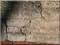
Cut Mark: Highfield House Farm
Cut bench mark on the gable end of a farm building. See http://www.geograph.org.uk/photo/5287894 for a wider view and http://www.bench-marks.org.uk/bm41219 for details.
Image: © Brian Westlake
Taken: 26 Jan 2012
0.05 miles
2
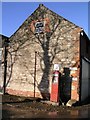
Farm building and fuel pump at Highfield House Farm
The building carries a cut bench mark near the drain pipe on the left. See http://www.geograph.org.uk/photo/5287890 for a closer view and http://www.bench-marks.org.uk/bm41219 for details.
Image: © Brian Westlake
Taken: 26 Jan 2012
0.05 miles