IMAGES TAKEN NEAR TO
Temple Grange, LINCOLN, LN5 0AX
Introduction
This page details the photographs taken nearby to Temple Grange, LN5 0AX by members of the Geograph project.
The Geograph project started in 2005 with the aim of publishing, organising and preserving representative images for every square kilometre of Great Britain, Ireland and the Isle of Man.

There are currently over 7.5m images from over14,400 individuals and you can help contribute to the project by visiting https://www.geograph.org.uk
Image Map
Images are licensed for reuse under creativecommons.org/licenses/by-sa/2.0
Notes
- Clicking on the map will re-center to the selected point.
- The higher the marker number, the further away the image location is from the centre of the postcode.
Image Listing (3 Images Found)
Images are licensed for reuse under creativecommons.org/licenses/by-sa/2.0
Image
Details
Distance
1
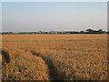
View towards Temple High Grange
Taken from Green Man Lane.
Image: © Jonathan Thacker
Taken: 10 Aug 2012
0.18 miles
2

Flush Bracket G1470: Temple High Grange Farm
Flush bracket on a cottage attached to farm buildings. See http://www.geograph.org.uk/photo/5280573 for a wider view and http://www.bench-marks.org.uk/bm13669 for details.
Image: © Brian Westlake
Taken: 2 Feb 2017
0.25 miles
3

Temple High Grange Farm
Cottage attached to farm buildings. By the porch and behind the bins is a flush bracket benchmark. See http://www.geograph.org.uk/photo/5280569 for a close-up and http://www.bench-marks.org.uk/bm13669 for details.
Image: © Brian Westlake
Taken: 2 Feb 2017
0.25 miles