IMAGES TAKEN NEAR TO
Dovecote Lane, LINCOLN, LN5 0AD
Introduction
This page details the photographs taken nearby to Dovecote Lane, LN5 0AD by members of the Geograph project.
The Geograph project started in 2005 with the aim of publishing, organising and preserving representative images for every square kilometre of Great Britain, Ireland and the Isle of Man.

There are currently over 7.5m images from over14,400 individuals and you can help contribute to the project by visiting https://www.geograph.org.uk
Image Map
Images are licensed for reuse under creativecommons.org/licenses/by-sa/2.0
Notes
- Clicking on the map will re-center to the selected point.
- The higher the marker number, the further away the image location is from the centre of the postcode.
Image Listing (76 Images Found)
Images are licensed for reuse under creativecommons.org/licenses/by-sa/2.0
Image
Details
Distance
1
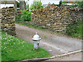
Coleby - hydrant on Dovecote Lane
For more information on this style of hydrant, please see Image
Image: © Dave Bevis
Taken: 17 Jun 2013
0.03 miles
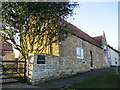
2
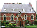
Coleby - former Wesleyan Chapel
At the southern end of Blind Lane.
Image: © Dave Bevis
Taken: 17 Jun 2013
0.04 miles
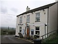
4
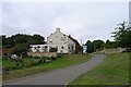
The Tempest Arms, Coleby
Situated on Hill Rise, at the top of the escarpment, the beer garden has excellent views over the Trent valley. Passed by the Viking Way.
Image: © Tim Heaton
Taken: 23 Aug 2013
0.08 miles
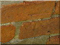
5
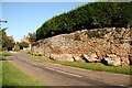
Coleby
Wonderfully textured stone wall built on a rocky outcrop on the cliff at Coleby
Image: © Richard Croft
Taken: 18 Sep 2008
0.08 miles
6
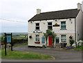
Coleby - The Tempest
On High Street. Part of the valley of the River Witham can be seen between the pub sign and the pub building.
Image: © Dave Bevis
Taken: 17 Jun 2013
0.08 miles
7
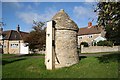
Wellhead and pump
18th century wellhead with a pump installed in 1896 and the well deepened in 1905.
Image: © Richard Croft
Taken: 8 Oct 2008
0.08 miles
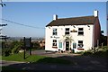
9
The Old House, Coleby
Cottage dating from the seventeenth and eighteenth centuries https://historicengland.org.uk/listing/the-list/list-entry/1061981?section=official-list-entry
Image: © Jonathan Thacker
Taken: 25 Feb 2022
0.09 miles
10
Ordnance Survey Cut Mark
This mark can be found on the wall of Hill Rise House.
For more detail see : http://www.bench-marks.org.uk/bm44993
Image: © Peter Wood
Taken: 22 Aug 2012
0.11 miles