IMAGES TAKEN NEAR TO
Bunkers Hill, LINCOLN, LN4 4YL
Introduction
This page details the photographs taken nearby to Bunkers Hill, LN4 4YL by members of the Geograph project.
The Geograph project started in 2005 with the aim of publishing, organising and preserving representative images for every square kilometre of Great Britain, Ireland and the Isle of Man.

There are currently over 7.5m images from over14,400 individuals and you can help contribute to the project by visiting https://www.geograph.org.uk
Image Map
Images are licensed for reuse under creativecommons.org/licenses/by-sa/2.0
Notes
- Clicking on the map will re-center to the selected point.
- The higher the marker number, the further away the image location is from the centre of the postcode.
Image Listing (7 Images Found)
Images are licensed for reuse under creativecommons.org/licenses/by-sa/2.0
Image
Details
Distance
1
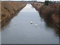
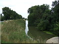
West fen drain
Water level low after dry winter. Taken from edge of concrete tunnel looking towards New York.
Image: © steve helliwell
Taken: 13 Feb 2006
0.08 miles
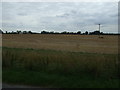
3
Moorside Road near Thornton Park Farm
Image: © Julian P Guffogg
Taken: 10 Sep 2017
0.12 miles
4
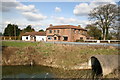
Bunkers Hill
Former pub at Bunkers Hill
Image: © Richard Croft
Taken: 5 Apr 2006
0.13 miles
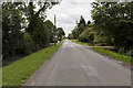
5
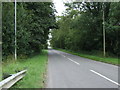
Road heading south at Bunker's Hill
Towards Gipsey Bridge.
Image: © JThomas
Taken: 10 Aug 2013
0.13 miles
7
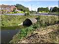
Culvert at Bunkers Hill
Howbridge Drain.
Image: © Jonathan Thacker
Taken: 13 Sep 2019
0.16 miles