IMAGES TAKEN NEAR TO
Ackrill Close, LINCOLN, LN4 4SH
Introduction
This page details the photographs taken nearby to Ackrill Close, LN4 4SH by members of the Geograph project.
The Geograph project started in 2005 with the aim of publishing, organising and preserving representative images for every square kilometre of Great Britain, Ireland and the Isle of Man.

There are currently over 7.5m images from over14,400 individuals and you can help contribute to the project by visiting https://www.geograph.org.uk
Image Map
Images are licensed for reuse under creativecommons.org/licenses/by-sa/2.0
Notes
- Clicking on the map will re-center to the selected point.
- The higher the marker number, the further away the image location is from the centre of the postcode.
Image Listing (29 Images Found)
Images are licensed for reuse under creativecommons.org/licenses/by-sa/2.0
Image
Details
Distance
1
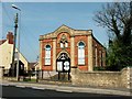
Coningsby Baptist Church, Coningsby
Built 1862.
Image: © Dave Hitchborne
Taken: 24 Apr 2004
0.08 miles
2
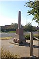
Coningsby War Memorial
Coningsby War Memorial Lincolnshire. R.A.F Coningsby, which is situated to the south of the village, is the home of The Battle of Britain Memorial Flight.
Image: © gary radford
Taken: 4 Oct 2009
0.14 miles
3
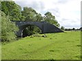
Old railway bridge near Coningsby
Although the embankment has been removed, clearly the cost of demolishing the bridge was not warranted.
Image: © Alan Murray-Rust
Taken: 1 Jul 2012
0.14 miles
4
Old railway bridge
Remains of the old railway bridge over the River Bain at Coningsby http://www.geograph.org.uk/photo/102197
Image: © Richard Croft
Taken: 13 May 2010
0.15 miles
5
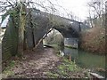
Railway Bridge at Coningsby
The arched brick built bridge and part of the embankment that carried the line over the River Bain, from Lincoln to Grimsby and Skegness, through New Bolingbroke and Stickney, still survives. The line closed in 1970 after 57 years of use.
Image: © Dave Hitchborne
Taken: 11 Dec 2003
0.15 miles
6
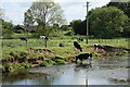
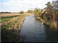
Cattle by the River Bain
Cattle grazing by the River Bain at Coningsby
Image: © Richard Croft
Taken: 28 May 2009
0.16 miles
7
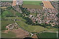
Disused railway crossing River Bain north of Coningsby: aerial 2019
Image: © Chris
Taken: 5 Aug 2019
0.17 miles
9
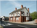
The Black Swan, Coningsby
Another of Coningsby's pubs.
Image: © Dave Hitchborne
Taken: 24 Apr 2004
0.17 miles
10
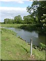
Marker post by the River Bain
The figures 4km are welded onto the top of the post, so this is presumably a distance marker, possibly by the local drainage authority. Local cattle clearly find it a convenient rubbing post!
Image: © Alan Murray-Rust
Taken: 1 Jul 2012
0.17 miles