IMAGES TAKEN NEAR TO
Leagate Road, LINCOLN, LN4 4RS
Introduction
This page details the photographs taken nearby to Leagate Road, LN4 4RS by members of the Geograph project.
The Geograph project started in 2005 with the aim of publishing, organising and preserving representative images for every square kilometre of Great Britain, Ireland and the Isle of Man.

There are currently over 7.5m images from over14,400 individuals and you can help contribute to the project by visiting https://www.geograph.org.uk
Image Map (Loading...)


Getting Data...Please wait
Leaflet Map data © OpenStreetMap
Images are licensed for reuse under creativecommons.org/licenses/by-sa/2.0
Notes
- Clicking on the map will re-center to the selected point.
- The higher the marker number, the further away the image location is from the centre of the postcode.
Image Listing (7 Images Found)
Images are licensed for reuse under creativecommons.org/licenses/by-sa/2.0
Image
Details
Distance
2
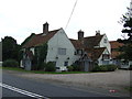
The Lea Gate Inn
Historic inn on Leagate Road near Coningsby. There was an inn on this site in 1542 and the current inn has evolved around a 16th century hall, 17th century parlour and early 18th century additions with extensive 19th & 20th century additions. Reputedly a 'fen guide house' ... a torch would blaze at night to guide travellers across the fens to the south and east. The modern day car-park in the foreground was formerly known as 'Gibbet Nook Close' - the site of a gibbet and numerous tales of hauntings abound.
Image: © Richard Croft
Taken: 14 Apr 2011
0.02 miles
4
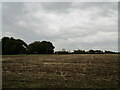
Stubble field alongside Leagate Road
Image: © Jonathan Thacker
Taken: 20 Oct 2020
0.12 miles
5
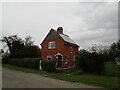
Former railway crossing keeper's cottage
Cross Keys Lane, Coningsby.
The railway was the Great Northern's 'New Line' opened in 1913 and closed in 1970. https://en.wikipedia.org/wiki/Kirkstead_and_Little_Steeping_Railway
Image: © Jonathan Thacker
Taken: 20 Oct 2020
0.22 miles
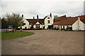
6
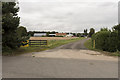
Entrance to Holt Farm
Off the B1192.
Image: © Julian P Guffogg
Taken: 10 Sep 2017
0.23 miles
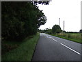
7
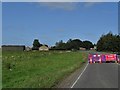
Leagate Road closure 17.9.20
Unexplained with no diversion signs. Grrr!
Image: © Neil Theasby
Taken: 17 Sep 2020
0.23 miles