IMAGES TAKEN NEAR TO
Clinton Park, LINCOLN, LN4 4PR
Introduction
This page details the photographs taken nearby to Clinton Park, LN4 4PR by members of the Geograph project.
The Geograph project started in 2005 with the aim of publishing, organising and preserving representative images for every square kilometre of Great Britain, Ireland and the Isle of Man.

There are currently over 7.5m images from over14,400 individuals and you can help contribute to the project by visiting https://www.geograph.org.uk
Image Map
Images are licensed for reuse under creativecommons.org/licenses/by-sa/2.0
Notes
- Clicking on the map will re-center to the selected point.
- The higher the marker number, the further away the image location is from the centre of the postcode.
Image Listing (14 Images Found)
Images are licensed for reuse under creativecommons.org/licenses/by-sa/2.0
Image
Details
Distance
1
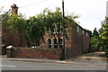
Interesting old building in Tattershall
A passer-by said he thought it was once a bank...
See: Image
Image: © Chris
Taken: 9 Sep 2012
0.10 miles
2
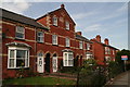
Rose Villas, Tattershall
An elegant old building from 1879.
Image: © Chris
Taken: 9 Sep 2012
0.12 miles
3
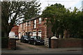
Interesting old building in Tattershall
See: Image
A passer-by said he thought it was once a bank, but viewed from this side it seems to have been some kind of stable and carriage shed.
The brickwork on the front looks more recent, so it may have had a second life.
Image: © Chris
Taken: 9 Sep 2012
0.12 miles
4
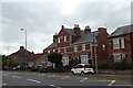
Unusual threesome of houses, Tattershall
This block has three houses, with the central one extending to three floors. The brickwork is noteworthy
Image: © David Smith
Taken: 19 Sep 2018
0.13 miles
5
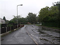
Wet High Street, Coningsby
The junction with Hunter's Lane is seen on the right of the picture.
Image: © J.Hannan-Briggs
Taken: 4 Sep 2011
0.19 miles
6
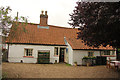
Pow Cottage
Historic mud & stud cottage on Tattershall High Street
Image: © Richard Croft
Taken: 13 Sep 2013
0.20 miles
7
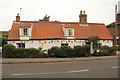
Pow Cottage
Mud & Stud cottage on Tattershall High Street, reputedly built in 1472, though more likely 17th century. On the right is the original cottage with central stack, with an addition to the left.
Image: © Richard Croft
Taken: 13 Sep 2013
0.21 miles
8
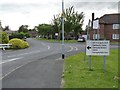
Thorpe Place
Housing estate developed by the ministry of Defence for personnel from the neighbouring RAF Coningsby.
Image: © Alan Murray-Rust
Taken: 1 Jul 2012
0.22 miles
9
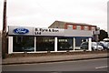
B.Eyre & Son
Ford car dealership in Tattershall
Image: © Richard Croft
Taken: 23 Feb 2008
0.23 miles
10
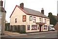
The Black Horse
Pub on Tattershall High Street
Image: © Richard Croft
Taken: 23 Feb 2008
0.23 miles