IMAGES TAKEN NEAR TO
Thorpe Road, LINCOLN, LN4 4PE
Introduction
This page details the photographs taken nearby to Thorpe Road, LN4 4PE by members of the Geograph project.
The Geograph project started in 2005 with the aim of publishing, organising and preserving representative images for every square kilometre of Great Britain, Ireland and the Isle of Man.

There are currently over 7.5m images from over14,400 individuals and you can help contribute to the project by visiting https://www.geograph.org.uk
Image Map (Loading...)


Getting Data...Please wait
Leaflet Map data © OpenStreetMap
Images are licensed for reuse under creativecommons.org/licenses/by-sa/2.0
Notes
- Clicking on the map will re-center to the selected point.
- The higher the marker number, the further away the image location is from the centre of the postcode.
Image Listing (26 Images Found)
Images are licensed for reuse under creativecommons.org/licenses/by-sa/2.0
Image
Details
Distance
1
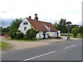
The Blue Bell, Tattershall Thorpe
This dates back to the early 17th century, though subsequently altered. The low walls are typical of the basic mud and stud construction, and the building would certainly have been thatched. Listed Grade II.
Image: © Alan Murray-Rust
Taken: 1 Jul 2012
0.07 miles
2
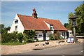
The Blue Bell
Haunted country inn with a history dating back to c1250, visited by King Henry VIII and popular with 617 and 627 squadrons during the war.
Image: © Richard Croft
Taken: 9 Jun 2008
0.07 miles
3
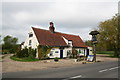
The Blue Bell
A wonderful grade II listed country inn with a history dating back to c1250, though the current structure is early 17th century mud & stud. Reputedly haunted, visited by King Henry VIII and popular with 617 and 627 squadrons during the war.
Image: © Richard Croft
Taken: 3 May 2006
0.07 miles
4
Forge Studio, Tattershall Thorpe
Re-use of the former village blacksmith's premises.
Image: © Alan Murray-Rust
Taken: 1 Jul 2012
0.08 miles
5
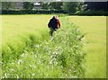
Walking through the barley
The tractor track is specifically for the footpath, and not for crop maintenance.
Image: © Alan Murray-Rust
Taken: 1 Jul 2012
0.09 miles
6
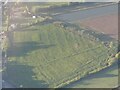
Cropmarks on field by Walnut Farm, Tattershall Thorpe: aerial 2022 (1)
Image: © Simon Tomson
Taken: 28 Sep 2022
0.09 miles
7
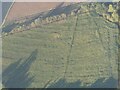
Cropmarks on field by Walnut Farm, Tattershall Thorpe: aerial 2022 (2)
Image: © Simon Tomson
Taken: 28 Sep 2022
0.09 miles
8
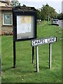
Parish Council Notice Board, Tattershall Thorpe
Stands next to the former chapel.
Image: © Dave Hitchborne
Taken: 8 Sep 2007
0.11 miles
9
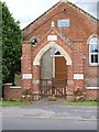
Tattershall Thorpe War Memorial
Constructed as a gateway to the Methodist Chapel http://www.geograph.org.uk/photo/3022064.
Image: © Alan Murray-Rust
Taken: 1 Jul 2012
0.12 miles
10
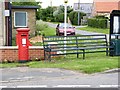
Tattershall - Woodhall Spa postbox (ref. LN4 99) and millennium seat
The postbox is a standard GVIR pillar box; the official name is unhelpful as it is nowhere near Woodhall Spa! Tattershall Thorpe would have been much more appropriate.
Image: © Alan Murray-Rust
Taken: 1 Jul 2012
0.12 miles