IMAGES TAKEN NEAR TO
Manor Road, LINCOLN, LN4 4NB
Introduction
This page details the photographs taken nearby to Manor Road, LN4 4NB by members of the Geograph project.
The Geograph project started in 2005 with the aim of publishing, organising and preserving representative images for every square kilometre of Great Britain, Ireland and the Isle of Man.

There are currently over 7.5m images from over14,400 individuals and you can help contribute to the project by visiting https://www.geograph.org.uk
Image Map (Loading...)


Getting Data...Please wait
Leaflet Map data © OpenStreetMap
Images are licensed for reuse under creativecommons.org/licenses/by-sa/2.0
Notes
- Clicking on the map will re-center to the selected point.
- The higher the marker number, the further away the image location is from the centre of the postcode.
Image Listing (106 Images Found)
Images are licensed for reuse under creativecommons.org/licenses/by-sa/2.0
Image
Details
Distance
1

Slope for sliding on
In this part of Lincolnshire, slopes for tobogganing on are few and far between, unless one wants to end up in a dyke! This mound has been created in open space in a small estate to the west of the village. It might even have been specifically intended for the purpose, although the presence of snow cannot be guaranteed.
Image: © Alan Murray-Rust
Taken: 20 Dec 2009
0.04 miles
2
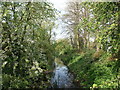
Beck at Tattershall
Leads to the disused Horncastle Canal.
Image: © Dave Hitchborne
Taken: 24 Apr 2004
0.07 miles
4
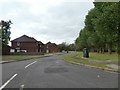
East Drive on Castlefields estate, Tattershall
Image: © David Smith
Taken: 19 Sep 2018
0.08 miles
5
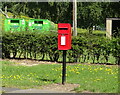
Elizabeth II postbox on Sleaford Road, Tattershall
Postbox No. LN4 62.
Image: © JThomas
Taken: 17 Jul 2020
0.08 miles
6

East Drive, Tattershall
East Drive, Tattershall
Image: © Alan Murray-Rust
Taken: 20 Dec 2009
0.10 miles
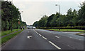
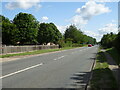
7

North Lane
Part of the housing estate on the north side of Sleaford Road. The way this estate is laid out suggests that it may have been built by the Ministry of Defence for personnel from the adjacent RAF Coningsby.
Image: © Alan Murray-Rust
Taken: 20 Dec 2009
0.10 miles
8

View from the castle (2)
Looking north of west to East Drive and the fens of the River Witham. Lincoln Cathedral is invisible in the distance.
Image: © Alan Murray-Rust
Taken: 20 Dec 2009
0.11 miles
10
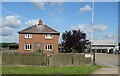
Station Farm, Tattershall
On Sleaford Road.
Image: © JThomas
Taken: 17 Jul 2020
0.15 miles