IMAGES TAKEN NEAR TO
Woodhall Road, LINCOLN, LN4 4JT
Introduction
This page details the photographs taken nearby to Woodhall Road, LN4 4JT by members of the Geograph project.
The Geograph project started in 2005 with the aim of publishing, organising and preserving representative images for every square kilometre of Great Britain, Ireland and the Isle of Man.

There are currently over 7.5m images from over14,400 individuals and you can help contribute to the project by visiting https://www.geograph.org.uk
Image Map
Images are licensed for reuse under creativecommons.org/licenses/by-sa/2.0
Notes
- Clicking on the map will re-center to the selected point.
- The higher the marker number, the further away the image location is from the centre of the postcode.
Image Listing (6 Images Found)
Images are licensed for reuse under creativecommons.org/licenses/by-sa/2.0
Image
Details
Distance
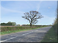
3
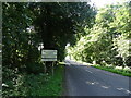
B1192, Tattershall Thorpe
Towards Woodhall Spa.
Image: © JThomas
Taken: 17 Jul 2020
0.18 miles
4
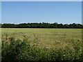
Cereal crop off the B1192, Tattershall Thorpe
Image: © JThomas
Taken: 17 Jul 2020
0.23 miles
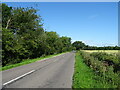
5
Lincolnshire road scene.
Photograph of the B1192 road passing through agricultural land near Tattershall Thorpe.
Image: © Mike Fowkes
Taken: 28 Apr 2006
0.23 miles
6
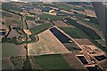
Crop marks in a field north of Tattershall: aerial 2018 (2)
See also Image
Image: © Chris
Taken: 11 Jul 2018
0.23 miles