IMAGES TAKEN NEAR TO
West Street, LINCOLN, LN4 4HS
Introduction
This page details the photographs taken nearby to West Street, LN4 4HS by members of the Geograph project.
The Geograph project started in 2005 with the aim of publishing, organising and preserving representative images for every square kilometre of Great Britain, Ireland and the Isle of Man.

There are currently over 7.5m images from over14,400 individuals and you can help contribute to the project by visiting https://www.geograph.org.uk
Image Map (Loading...)


Getting Data...Please wait
Leaflet Map data © OpenStreetMap
Images are licensed for reuse under creativecommons.org/licenses/by-sa/2.0
Notes
- Clicking on the map will re-center to the selected point.
- The higher the marker number, the further away the image location is from the centre of the postcode.
Image Listing (56 Images Found)
Images are licensed for reuse under creativecommons.org/licenses/by-sa/2.0
Image
Details
Distance
1
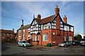
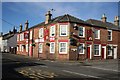
Ye Cross Keys Inn
Former inn at Billinghay
Image: © Richard Croft
Taken: 4 Feb 2008
0.09 miles
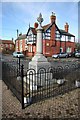
3

War memorial in Billinghay
Sited in Market Place though markets no longer take place here.
Image: © Bill Boaden
Taken: 10 Jul 2024
0.11 miles
4
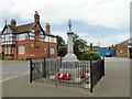
Billinghay War Memorial
The memorial bear the names of 44 men and women who died in WW1 and of seven who died in WW2.
Details can be seen here
http://www.roll-of-honour.com/Lincolnshire/Billinghay.html
Image: © Adrian S Pye
Taken: 5 Jun 2018
0.11 miles
5
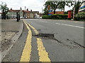
Four inch deep pot-hole to catch out the unwary at Billinghay
Unmarked, though potentially dangerous.
Image: © Adrian S Pye
Taken: 5 Jun 2018
0.11 miles
6
The Ship Inn
Popular hostelry in Billinghay http://www.the-shipinn.co.uk/
Image: © Richard Croft
Taken: 4 Feb 2008
0.11 miles
7
Road junction next to church
Junction of Church Street and Church Lane
Image: © John Firth
Taken: 8 Jun 2011
0.13 miles
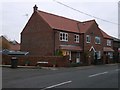
8
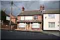
Old Butcher's Arms
Former pub on Bridge Street in Billinghay
Image: © Richard Croft
Taken: 13 Oct 2008
0.13 miles
9
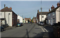
Bridge Street, Billinghay
Billinghay is quite a substantial village extended some distance west of the A153.
Image: © Andrew Hill
Taken: 7 Oct 2009
0.13 miles
10
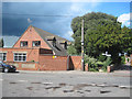
Billinghay, old school location
This housing at the junction of Old School Lane and Church Street stands on the location of the old primary school. The school used to carry an Ordnance Survey flush bracket, see http://www.bench-marks.org.uk/bm13330 for details.
Image: © Brian Westlake
Taken: 26 Nov 2015
0.13 miles