IMAGES TAKEN NEAR TO
Wood Lane, LINCOLN, LN4 4AB
Introduction
This page details the photographs taken nearby to Wood Lane, LN4 4AB by members of the Geograph project.
The Geograph project started in 2005 with the aim of publishing, organising and preserving representative images for every square kilometre of Great Britain, Ireland and the Isle of Man.

There are currently over 7.5m images from over14,400 individuals and you can help contribute to the project by visiting https://www.geograph.org.uk
Image Map (Loading...)


Getting Data...Please wait
Leaflet Map data © OpenStreetMap
Images are licensed for reuse under creativecommons.org/licenses/by-sa/2.0
Notes
- Clicking on the map will re-center to the selected point.
- The higher the marker number, the further away the image location is from the centre of the postcode.
Image Listing (5 Images Found)
Images are licensed for reuse under creativecommons.org/licenses/by-sa/2.0
Image
Details
Distance
1
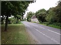
Wood Lane, near Old Wood
Woodside cottage on the right.
Image: © J.Hannan-Briggs
Taken: 20 Aug 2011
0.07 miles
2
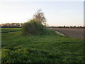
Hedgerow near South Kyme
The plantation to the left of the hedge is close to The Grange. This is a very different landscape from that of the Fens which are only a few hundred metres away.
Image: © Jonathan Thacker
Taken: 23 Apr 2015
0.14 miles
3
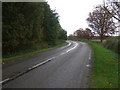
Wood Lane (B1395)
Heading west beside Old Wood.
Image: © JThomas
Taken: 18 Oct 2014
0.21 miles
4
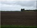
Field towards The Grange
North of Wood Lane (B1395).
Image: © JThomas
Taken: 18 Oct 2014
0.21 miles
5
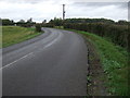
A bend in Wood Lane (B1395)
Heading north west towards North Kyme.
Image: © JThomas
Taken: 18 Oct 2014
0.25 miles