IMAGES TAKEN NEAR TO
High Street, LINCOLN, LN4 3SN
Introduction
This page details the photographs taken nearby to High Street, LN4 3SN by members of the Geograph project.
The Geograph project started in 2005 with the aim of publishing, organising and preserving representative images for every square kilometre of Great Britain, Ireland and the Isle of Man.

There are currently over 7.5m images from over14,400 individuals and you can help contribute to the project by visiting https://www.geograph.org.uk
Image Map
Images are licensed for reuse under creativecommons.org/licenses/by-sa/2.0
Notes
- Clicking on the map will re-center to the selected point.
- The higher the marker number, the further away the image location is from the centre of the postcode.
Image Listing (27 Images Found)
Images are licensed for reuse under creativecommons.org/licenses/by-sa/2.0
Image
Details
Distance
1
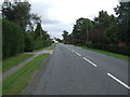
High Street (B1189), Walcott
Looking south east.
Image: © JThomas
Taken: 5 Sep 2015
0.03 miles
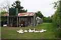
2
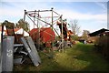
Walcott farmyard
Part of a farmyard off High Street Walcott
Image: © Richard Croft
Taken: 27 Jan 2008
0.03 miles
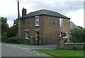
5
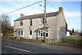
High Street Walcott
Empty house on a large plot on Walcott High Street
Image: © Richard Croft
Taken: 27 Jan 2008
0.11 miles
6
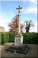
Walcott War Memorial
By St.Oswald's church
Image: © Richard Croft
Taken: 27 Jan 2008
0.16 miles
7
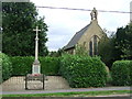
War memorial and church, Walcott
On High Street (B1189).
Image: © JThomas
Taken: 5 Sep 2015
0.16 miles
8
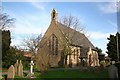
St.Oswald's church
1852 stock brick with lancets and bellcote
Image: © Richard Croft
Taken: 27 Jan 2008
0.17 miles
10

St Oswald, Walcott
A new and unusual looking label stop and moulding.
Image: © Dave Hitchborne
Taken: 20 May 2008
0.17 miles