IMAGES TAKEN NEAR TO
Foster Close, LINCOLN, LN4 3SE
Introduction
This page details the photographs taken nearby to Foster Close, LN4 3SE by members of the Geograph project.
The Geograph project started in 2005 with the aim of publishing, organising and preserving representative images for every square kilometre of Great Britain, Ireland and the Isle of Man.

There are currently over 7.5m images from over14,400 individuals and you can help contribute to the project by visiting https://www.geograph.org.uk
Image Map
Images are licensed for reuse under creativecommons.org/licenses/by-sa/2.0
Notes
- Clicking on the map will re-center to the selected point.
- The higher the marker number, the further away the image location is from the centre of the postcode.
Image Listing (24 Images Found)
Images are licensed for reuse under creativecommons.org/licenses/by-sa/2.0
Image
Details
Distance
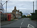
2
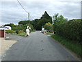
Fen Road, Timberland
Heading east from the village.
Image: © JThomas
Taken: 5 Sep 2015
0.10 miles
4
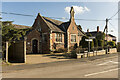
The Old School, Timberland
Dates from 1843.
Image: © Julian P Guffogg
Taken: 27 Feb 2021
0.10 miles
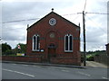
5
The Old School, Church Lane, Timberland
Grade II Listed school of 1843 altered about 1890. Now a house.
Image: © Jo and Steve Turner
Taken: 7 Mar 2015
0.10 miles
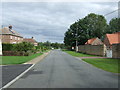
7
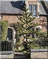
Monkey Puzzle tree, Timberland
Next to the Old School.
Image: © Julian P Guffogg
Taken: 27 Feb 2021
0.11 miles
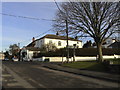
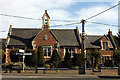
8
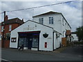
Former Post Office and shop, Timberland
On Church Lane.
Closed permanently in July, 2015.
Image: © JThomas
Taken: 5 Sep 2015
0.12 miles