IMAGES TAKEN NEAR TO
Moor Lane, LINCOLN, LN4 3RB
Introduction
This page details the photographs taken nearby to Moor Lane, LN4 3RB by members of the Geograph project.
The Geograph project started in 2005 with the aim of publishing, organising and preserving representative images for every square kilometre of Great Britain, Ireland and the Isle of Man.

There are currently over 7.5m images from over14,400 individuals and you can help contribute to the project by visiting https://www.geograph.org.uk
Image Map
Images are licensed for reuse under creativecommons.org/licenses/by-sa/2.0
Notes
- Clicking on the map will re-center to the selected point.
- The higher the marker number, the further away the image location is from the centre of the postcode.
Image Listing (14 Images Found)
Images are licensed for reuse under creativecommons.org/licenses/by-sa/2.0
Image
Details
Distance
2
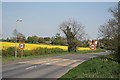
The western edge of Martin village
The yellow panels of the speed restriction signs almost blend into the yellow rape.
Image: © Alan Murray-Rust
Taken: 29 Apr 2007
0.02 miles
5
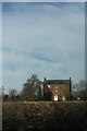
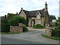
Martin Manor House, Timberland Road, Martin
Grade II Listed farmhouse of about 1780.
Image: © Jo and Steve Turner
Taken: 7 Mar 2015
0.16 miles
9
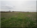
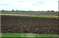
Grass track, Martin Moor
At this time of year and in this light not so easily distinguishable from the surrounding fields.
Image: © Jonathan Thacker
Taken: 4 Mar 2020
0.23 miles
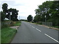
10
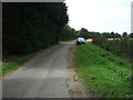
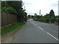
North Moor Lane
Heading north west from Martin.
Image: © JThomas
Taken: 5 Sep 2015
0.23 miles