IMAGES TAKEN NEAR TO
Sleaford Road, LINCOLN, LN4 3PU
Introduction
This page details the photographs taken nearby to Sleaford Road, LN4 3PU by members of the Geograph project.
The Geograph project started in 2005 with the aim of publishing, organising and preserving representative images for every square kilometre of Great Britain, Ireland and the Isle of Man.

There are currently over 7.5m images from over14,400 individuals and you can help contribute to the project by visiting https://www.geograph.org.uk
Image Map (Loading...)


Getting Data...Please wait
Leaflet Map data © OpenStreetMap
Images are licensed for reuse under creativecommons.org/licenses/by-sa/2.0
Notes
- Clicking on the map will re-center to the selected point.
- The higher the marker number, the further away the image location is from the centre of the postcode.
Image Listing (6 Images Found)
Images are licensed for reuse under creativecommons.org/licenses/by-sa/2.0
Image
Details
Distance
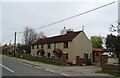
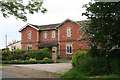
2
Entering Dorrington
Heading north on Sleaford Road (B1188).
Image: © JThomas
Taken: 1 Apr 2021
0.02 miles
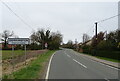
3
Junction of Moor Lane and Sleaford Road
Sleaford Road is the B1188.
Image: © Julian P Guffogg
Taken: 13 Apr 2016
0.03 miles
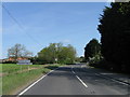
6
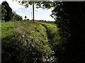
Disappearing Fields
The road level on the left demonstrates how much the field level on the right has fallen.
Image: © Michael Patterson
Taken: 9 Oct 2006
0.12 miles