IMAGES TAKEN NEAR TO
Lincoln Road, LINCOLN, LN4 3PT
Introduction
This page details the photographs taken nearby to Lincoln Road, LN4 3PT by members of the Geograph project.
The Geograph project started in 2005 with the aim of publishing, organising and preserving representative images for every square kilometre of Great Britain, Ireland and the Isle of Man.

There are currently over 7.5m images from over14,400 individuals and you can help contribute to the project by visiting https://www.geograph.org.uk
Image Map (Loading...)


Getting Data...Please wait
Leaflet Map data © OpenStreetMap
Images are licensed for reuse under creativecommons.org/licenses/by-sa/2.0
Notes
- Clicking on the map will re-center to the selected point.
- The higher the marker number, the further away the image location is from the centre of the postcode.
Image Listing (29 Images Found)
Images are licensed for reuse under creativecommons.org/licenses/by-sa/2.0
Image
Details
Distance
1
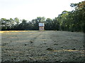
Stubble field and water tank, Dorrington
Long evening shadows.
Image: © Jonathan Thacker
Taken: 28 Aug 2021
0.04 miles
2
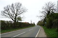
B1188 towards Digby
Heading north from Dorrington.
Image: © JThomas
Taken: 1 Apr 2021
0.06 miles
3
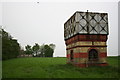
Disused water tower
This disused water tower built in 1910 is on a hill by the church, it once served the village of Dorrington
Image: © Richard Croft
Taken: 8 May 2006
0.07 miles
4
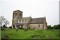
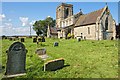
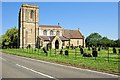
St.James & St.John's church, Dorrington, Lincs.
Chronologically - a bold Transitional tower, 13th century arcades and chancel, some Decorated windows and bell openings and Perpendicular clerestorey. The church stands north of the village on a rise with views all round.
Image: © Richard Croft
Taken: 8 May 2006
0.10 miles
5
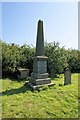
St James & St John Churchyard, Dorrington
A memorial to the Pickworth family by John Pickworth, of England, who died in America.
Image: © Dave Hitchborne
Taken: 26 Aug 2013
0.13 miles
6
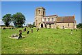
The Church of St James & St John, Dorrington
This church was tenth on the list to be photographed on this day - http://www.geograph.org.uk/photo/3624846 The church was built on a hill overlooking the village. The east wall was rebuilt in 1330. The village had a small chapel of ease, but this was taken down in 1698.
Image: © Dave Hitchborne
Taken: 26 Aug 2013
0.13 miles
7
The Church of St James & St John, Dorrington
This church was tenth on the list to be photographed on this day - http://www.geograph.org.uk/photo/3624846 The church was built on a hill overlooking the village. The east wall was rebuilt in 1330. The village had a small chapel of ease, but this was taken down in 1698.
Image: © Dave Hitchborne
Taken: 26 Aug 2013
0.13 miles
8
The Church of St James & St John, Dorrington
This church was tenth on the list to be photographed on this day - http://www.geograph.org.uk/photo/3624846 The church was built on a hill overlooking the village. The east wall was rebuilt in 1330. The village had a small chapel of ease, but this was taken down in 1698.
Image: © Dave Hitchborne
Taken: 26 Aug 2013
0.13 miles
9
The Church of St James & St John, Dorrington
This church was tenth on the list to be photographed on this day - http://www.geograph.org.uk/photo/3624846 The church was built on a hill overlooking the village. The east wall was rebuilt in 1330. The village had a small chapel of ease, but this was taken down in 1698.
Image: © Dave Hitchborne
Taken: 26 Aug 2013
0.13 miles
10
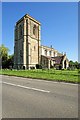
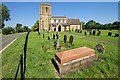
The Church of St James & St John, Dorrington
The church was built on a hill overlooking the village. The east wall was rebuilt in 1330. The village had a small chapel of ease, but this was taken down in 1698.
Image: © Dave Hitchborne
Taken: 26 Aug 2013
0.14 miles