IMAGES TAKEN NEAR TO
Rowston, LINCOLN, LN4 3PS
Introduction
This page details the photographs taken nearby to LN4 3PS by members of the Geograph project.
The Geograph project started in 2005 with the aim of publishing, organising and preserving representative images for every square kilometre of Great Britain, Ireland and the Isle of Man.

There are currently over 7.5m images from over14,400 individuals and you can help contribute to the project by visiting https://www.geograph.org.uk
Image Map (Loading...)


Getting Data...Please wait
Leaflet Map data © OpenStreetMap
Images are licensed for reuse under creativecommons.org/licenses/by-sa/2.0
Notes
- Clicking on the map will re-center to the selected point.
- The higher the marker number, the further away the image location is from the centre of the postcode.
Image Listing (7 Images Found)
Images are licensed for reuse under creativecommons.org/licenses/by-sa/2.0
Image
Details
Distance
2
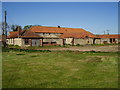
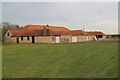
Disused farm buildings at Sheffield House Farm
Taken from the footpath which continues to a large development with no name on the B1191. It could be Scopwick Heath but as yet no one has submitted a picture.
Image: © Ken Brockway
Taken: 1 May 2007
0.07 miles