IMAGES TAKEN NEAR TO
Butters Corner, LINCOLN, LN4 3GE
Introduction
This page details the photographs taken nearby to Butters Corner, LN4 3GE by members of the Geograph project.
The Geograph project started in 2005 with the aim of publishing, organising and preserving representative images for every square kilometre of Great Britain, Ireland and the Isle of Man.

There are currently over 7.5m images from over14,400 individuals and you can help contribute to the project by visiting https://www.geograph.org.uk
Image Map
Images are licensed for reuse under creativecommons.org/licenses/by-sa/2.0
Notes
- Clicking on the map will re-center to the selected point.
- The higher the marker number, the further away the image location is from the centre of the postcode.
Image Listing (27 Images Found)
Images are licensed for reuse under creativecommons.org/licenses/by-sa/2.0
Image
Details
Distance
1
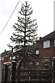
Monkey Puzzle Tree, Alfred Avenue, Metheringham
Planted rather near the house.
Image: © J.Hannan-Briggs
Taken: 24 Mar 2013
0.09 miles
2
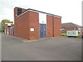
Metheringham Telephone Exchange
Situated on the B1189 Lincoln Road, this TE is of a standard design dating from the 1970s and would have replaced a smaller building in the same village. It has the code SLMIM and provides telephone and broadband services to 3,043 residential and 145 non-residential premises in Metheringham, Ashby de la Launde, Blankney, Digby, Dunston, Kirkby Green, Nocton, Rowston, Scopwick, Wasps Nest and the surrounding area. A square white BT warning notice can be seen on this TE whilst to the right of the photo are two pale green generators. The numbering range of this TE is (01526) 32xxxx, the (01526) referring to the Martin group of eight TEs, and its postcode is LN4 3EE.
Image: © David Hillas
Taken: 19 Jul 2019
0.10 miles
3
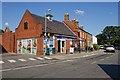
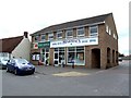
High Street, Metheringham
The village store, which appears to have been built to blend in with its surroundings.
Image: © Dave Hitchborne
Taken: 26 Aug 2013
0.15 miles
4
High Street, Metheringham
The Pharmacy and Post Office.
Image: © Dave Hitchborne
Taken: 20 May 2008
0.16 miles
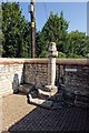
5
High Street, Metheringham
The Market Cross - Regarded as the centre of the village, there has been a market cross here since at least 1835. That cross was replaced in 1911 to celebrate George V's coronation. Remnants of the previous cross were moved and set against the wall just opposite. In 1947 a new cross was built after the 1911 cross was knocked down by a US army lorry. A time capsule was placed beneath the cross, which contains: a list of the donors, a copy of the Holy Bible, Lord Tennyson’s works, the Times newspaper of June 22nd and some coins.
Image: © Dave Hitchborne
Taken: 26 Aug 2013
0.16 miles
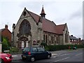
6
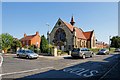
Methodist Church, Metheringham
Last photographed in 2008 - http://www.geograph.org.uk/photo/813406
Image: © Dave Hitchborne
Taken: 26 Aug 2013
0.16 miles
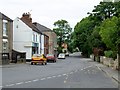
7
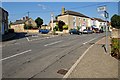
High Street, Metheringham
At first glance this looks like a line of traffic, but no, they're parked cars. Lloyds TSB is in the distance, as is The Star & Garter public house.
Image: © Dave Hitchborne
Taken: 20 May 2008
0.16 miles
8
High Street, Metheringham
The Market Cross - Regarded as the centre of the village, there has been a market cross here since at least 1835. That cross was replaced in 1911 to celebrate George V's coronation. Remnants of the previous cross, seen here, were moved and set against the wall just opposite. In 1947 a new cross was built after the 1911 cross was knocked down by a US army lorry. A time capsule was placed beneath the cross, which contains: a list of the donors, a copy of the Holy Bible, Lord Tennyson’s works, the Times newspaper of June 22nd and some coins.
Image: © Dave Hitchborne
Taken: 26 Aug 2013
0.17 miles
9
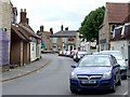
High Street, Metheringham
Looking towards Dunston Road
Image: © Dave Hitchborne
Taken: 20 May 2008
0.17 miles