IMAGES TAKEN NEAR TO
Highfields Rise, LINCOLN, LN4 3DD
Introduction
This page details the photographs taken nearby to Highfields Rise, LN4 3DD by members of the Geograph project.
The Geograph project started in 2005 with the aim of publishing, organising and preserving representative images for every square kilometre of Great Britain, Ireland and the Isle of Man.

There are currently over 7.5m images from over14,400 individuals and you can help contribute to the project by visiting https://www.geograph.org.uk
Image Map
Images are licensed for reuse under creativecommons.org/licenses/by-sa/2.0
Notes
- Clicking on the map will re-center to the selected point.
- The higher the marker number, the further away the image location is from the centre of the postcode.
Image Listing (3 Images Found)
Images are licensed for reuse under creativecommons.org/licenses/by-sa/2.0
Image
Details
Distance
1
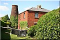
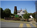
Metheringham Windmill
Disused windmill and Mill House at Metheringham
Former tall six sail mill dated H.B.1867. As each sail was lost it was not replaced, the other ones being juggled around to maintain the balance. It ran with 6, then 4, then 2 and finally 3 sails, in which form it finished work in the 1920's or early 1930's http://microsites.lincolnshire.gov.uk/Windmills/section.asp?catId=3372
Image: © Richard Croft
Taken: 9 Jun 2008
0.13 miles
3
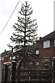
Monkey Puzzle Tree, Alfred Avenue, Metheringham
Planted rather near the house.
Image: © J.Hannan-Briggs
Taken: 24 Mar 2013
0.22 miles