IMAGES TAKEN NEAR TO
Bloxholm, LINCOLN, LN4 3AT
Introduction
This page details the photographs taken nearby to LN4 3AT by members of the Geograph project.
The Geograph project started in 2005 with the aim of publishing, organising and preserving representative images for every square kilometre of Great Britain, Ireland and the Isle of Man.

There are currently over 7.5m images from over14,400 individuals and you can help contribute to the project by visiting https://www.geograph.org.uk
Image Map
Images are licensed for reuse under creativecommons.org/licenses/by-sa/2.0
Notes
- Clicking on the map will re-center to the selected point.
- The higher the marker number, the further away the image location is from the centre of the postcode.
Image Listing (4 Images Found)
Images are licensed for reuse under creativecommons.org/licenses/by-sa/2.0
Image
Details
Distance
1
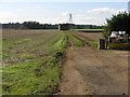
Footpath and Skip
This footpath leads to Bloxholm.
Image: © Michael Patterson
Taken: 9 Oct 2006
0.12 miles
2
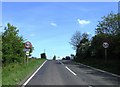
Through the arched window..
.. can be seen St James' & St John's Church, Dorrington. The beginnings of a roadside sculpture on the B1188 near Bloxholme. Quite possibly a hazard as it is a bit of a distraction on this fast-moving road.
Image: © Ian Paterson
Taken: 14 Mar 2009
0.15 miles
3
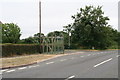
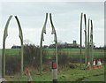
Themed bus shelter by the Pinfold
Designed by local artist Richard Bett, the theme of the arches takes inspiration from the window architecture of Digby’s Grade One listed church, St. Thomas a Becket.
The arches are intended to be a landmark piece, promoting the ‘Spires and Steeples’ trail and also hinting at other features to be discovered nearby.
See: http://parishes.lincolnshire.gov.uk/Digby/section.asp?catId=15301
There are more arches (without the bus shelter) by the road a few hundred yards to the south. See: Image
Image: © Chris
Taken: 20 Jul 2013
0.23 miles