IMAGES TAKEN NEAR TO
Field Farm Lane, LINCOLN, LN4 3AF
Introduction
This page details the photographs taken nearby to Field Farm Lane, LN4 3AF by members of the Geograph project.
The Geograph project started in 2005 with the aim of publishing, organising and preserving representative images for every square kilometre of Great Britain, Ireland and the Isle of Man.

There are currently over 7.5m images from over14,400 individuals and you can help contribute to the project by visiting https://www.geograph.org.uk
Image Map
Images are licensed for reuse under creativecommons.org/licenses/by-sa/2.0
Notes
- Clicking on the map will re-center to the selected point.
- The higher the marker number, the further away the image location is from the centre of the postcode.
Image Listing (35 Images Found)
Images are licensed for reuse under creativecommons.org/licenses/by-sa/2.0
Image
Details
Distance
1
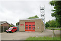
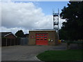
Metheringham fire station
Metheringham fire station, Fen Road, Metheringham, Lincolnshire
Image: © Kevin Hale
Taken: 1 Jun 2008
0.05 miles
3
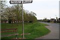
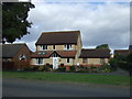
Green space in Metheringham
Opposite the Fire Station.
Image: © Chris
Taken: 9 Apr 2017
0.07 miles
4
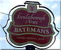
Sign for the Londesborough Arms, Metheringham
Image: © JThomas
Taken: 5 Sep 2015
0.08 miles
5
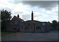
The Londesborough Arms, Metheringham
On Fen Road.
Image: © JThomas
Taken: 5 Sep 2015
0.10 miles
6
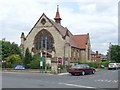
Methodist Church, Metheringham
A close-up of the 100-year-old church.
Image: © Dave Hitchborne
Taken: 20 May 2008
0.11 miles
8
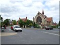
Methodist Church, Metheringham
At the junction of High Street and Fen Road is this Methodist Church. I'm pleased to have photographed it celebrating its centenary.
Image: © Dave Hitchborne
Taken: 20 May 2008
0.11 miles