IMAGES TAKEN NEAR TO
Chichester Road, LINCOLN, LN4 2TP
Introduction
This page details the photographs taken nearby to Chichester Road, LN4 2TP by members of the Geograph project.
The Geograph project started in 2005 with the aim of publishing, organising and preserving representative images for every square kilometre of Great Britain, Ireland and the Isle of Man.

There are currently over 7.5m images from over14,400 individuals and you can help contribute to the project by visiting https://www.geograph.org.uk
Image Map (Loading...)


Getting Data...Please wait
Leaflet Map data © OpenStreetMap
Images are licensed for reuse under creativecommons.org/licenses/by-sa/2.0
Notes
- Clicking on the map will re-center to the selected point.
- The higher the marker number, the further away the image location is from the centre of the postcode.
Image Listing (20 Images Found)
Images are licensed for reuse under creativecommons.org/licenses/by-sa/2.0
Image
Details
Distance
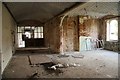
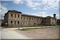
1
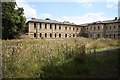
St.John's Hospital
The County Pauper Lunatic Asylum opened in 1852, after numerous name changes it became St.John's hospital in the 1960s. Closed in 1989, the site has been partly developed with modern housing but 20 years later most of the buildings remain empty and semi-derelict.
Image: © Richard Croft
Taken: 13 Aug 2009
0.04 miles
2
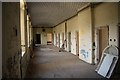
St.John's Hospital
The County Pauper Lunatic Asylum opened in 1852, after numerous name changes it became St.John's hospital in the 1960s. Closed in 1989, the site has been partly developed with modern housing but 20 years later most of the buildings remain empty and semi-derelict.
Image: © Richard Croft
Taken: 13 Aug 2009
0.04 miles
3
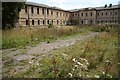
St.John's Hospital
The County Pauper Lunatic Asylum opened in 1852, after numerous name changes it became St.John's hospital in the 1960s. Closed in 1989, the site has been partly developed with modern housing but 20 years later most of the buildings remain empty and semi-derelict.
Image: © Richard Croft
Taken: 13 Aug 2009
0.05 miles
4
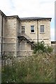
St.John's Hospital
The County Pauper Lunatic Asylum opened in 1852, after numerous name changes it became St.John's hospital in the 1960s. Closed in 1989, the site has been partly developed with modern housing but 20 years later most of the buildings remain empty and semi-derelict.
Image: © Richard Croft
Taken: 13 Aug 2009
0.06 miles
5
St.John's Hospital
The County Pauper Lunatic Asylum opened in 1852, after numerous name changes it became St.John's hospital in the 1960s. Closed in 1989, the site has been partly developed with modern housing but 20 years later most of the buildings remain empty and semi-derelict.
Image: © Richard Croft
Taken: 13 Aug 2009
0.06 miles
6
St.John's Hospital
The County Pauper Lunatic Asylum opened in 1852, after numerous name changes it became St.John's hospital in the 1960s. Closed in 1989, the site has been partly developed with modern housing but 20 years later most of the buildings remain empty and semi-derelict.
Image: © Richard Croft
Taken: 13 Aug 2009
0.08 miles
7
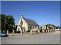
The chapel at the former St. John's Hospital
Now converted to housing.
Image: © Jonathan Thacker
Taken: 29 Jun 2019
0.12 miles
8
St John's Former Psychiatric Hospital
Image: © J.Hannan-Briggs
Taken: 10 Nov 2012
0.12 miles
9

St John's Hospital, Bracebridge Heath, Lincolnshire
Main entrance to St John's mental hospital in Bracebridge Heath, now closed.
Image: © Gary Brothwell
Taken: 1 Sep 2010
0.13 miles
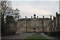
10

Former hospital, Bracebridge Heath
The main building of the former County Pauper Lunatic Asylum, built in 1849-52 by Hamilton & Medland, and then Hamilton and Thomas Percy. Grade II listed.
Many later additions; it was later St John's Hospital. The hospital closed in 1989, and the site was here being redeveloped for housing. A surprising number of the original buildings have survived.
Image: © Stephen Richards
Taken: 17 Jun 2015
0.13 miles