IMAGES TAKEN NEAR TO
St. Johns Road, LINCOLN, LN4 2PT
Introduction
This page details the photographs taken nearby to St. Johns Road, LN4 2PT by members of the Geograph project.
The Geograph project started in 2005 with the aim of publishing, organising and preserving representative images for every square kilometre of Great Britain, Ireland and the Isle of Man.

There are currently over 7.5m images from over14,400 individuals and you can help contribute to the project by visiting https://www.geograph.org.uk
Image Map (Loading...)


Getting Data...Please wait
Leaflet Map data © OpenStreetMap
Images are licensed for reuse under creativecommons.org/licenses/by-sa/2.0
Notes
- Clicking on the map will re-center to the selected point.
- The higher the marker number, the further away the image location is from the centre of the postcode.
Image Listing (23 Images Found)
Images are licensed for reuse under creativecommons.org/licenses/by-sa/2.0
Image
Details
Distance
2
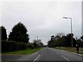
Bracebridge Heath, Grantham Road
The A607 briefly follows the route of the Roman Ermine Street at Bracebridge Heath.
Image: © David Dixon
Taken: 5 Aug 2014
0.14 miles
4
Bracebridge Heath reservoir
Built about 1912, the reservoir and tower were put in place to combat a severe outbreak of typhoid. The reservoir is fed by a 22 mile pipeline from Elkesley in Nottinghamshire.
Image: © Matthew Smith
Taken: 18 Feb 2006
0.16 miles
6
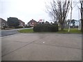
Petrol station forecourt on Sleaford Road
Image: © David Howard
Taken: 13 Jan 2018
0.17 miles
7
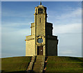
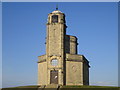
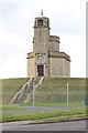
Pump House, Bracebridge Service Reservoir, Grantham Road, Bracebridge Heath
Grade II Listed Pump House designed by Niel McKechnie Barron 1912. The typhoid epidemic in 1904/5 resulted in 131 deaths in Lincoln. Contaminated water from Hartsholme Reservoir got the blame and so a new source was found at Elkesley and piped to Westgate Water Tower. The surplus is passed to the six million gallon Bracebridge Heath Reservoir by gravitation. Steam engines pumped the water from Elkesley until 1973 when one blew up and had to be replaced with the modern electric station. The Reservoir was constructed to replace an 'old' open reservoir on Bracebridge Heath on London Road which had been built in 1871. It was left water-filled from 1912 as an emergency supply in case of fire at the Bracebridge Asylum until the new 'Hospital' water tower was erected and connected to the mains in 1925.
Image: © Jo and Steve Turner
Taken: 31 Dec 2005
0.17 miles
9
Tower at Bracebridge covered reservoir
Image: © J.Hannan-Briggs
Taken: 21 Oct 2012
0.18 miles
10
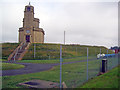
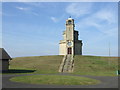
Bracebridge Heath Water Tower and Reservoir
Water pumping station and reservoir located on Grantham Road. In 1904/5 a typhoid epidemic in Lincoln resulted in 131 deaths. Contaminated water supplies were blamed and it was necessary to improve the quality of the supply. A new source of supply at Elkesley (Notts - see http://www.retfordpeople.co.uk/Water-way-celebrate-history/story-12817308-detail/story.html ) was used and from 1911 to the present day water pumped from Elkesley goes into Westgate water tower (see Image ) with the surplus passed by gravitation to Bracebridge Heath Reservoir. It is a covered reservoir with a capacity of six million gallons which serves the low districts of Lincoln as well as Bracebridge Heath and RAF Waddington. It has recently had a booster station fitted and has been linked to Leaderham service reservoir.
Image: © Trevor Rickard
Taken: 5 Aug 2012
0.18 miles