IMAGES TAKEN NEAR TO
Davy's Lane, LINCOLN, LN4 2NB
Introduction
This page details the photographs taken nearby to Davy's Lane, LN4 2NB by members of the Geograph project.
The Geograph project started in 2005 with the aim of publishing, organising and preserving representative images for every square kilometre of Great Britain, Ireland and the Isle of Man.

There are currently over 7.5m images from over14,400 individuals and you can help contribute to the project by visiting https://www.geograph.org.uk
Image Map
Images are licensed for reuse under creativecommons.org/licenses/by-sa/2.0
Notes
- Clicking on the map will re-center to the selected point.
- The higher the marker number, the further away the image location is from the centre of the postcode.
Image Listing (37 Images Found)
Images are licensed for reuse under creativecommons.org/licenses/by-sa/2.0
Image
Details
Distance

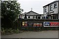
4
Co-op Funeral Services, Bracebridge Heath
Image: © Jonathan Thacker
Taken: 27 Mar 2015
0.09 miles
8
The Blacksmiths pub, Bracebridge Heath
Image: © David Howard
Taken: 24 Jun 2019
0.11 miles
9
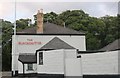
The Blacksmiths pub, Bracebridge Heath
Here is the other side https://www.geograph.org.uk/photo/6194811
Image: © David Howard
Taken: 6 Aug 2019
0.11 miles
10
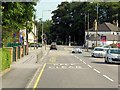
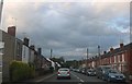
Grantham Road, Bracebridge Heath
The traffic lights at Bracebridge Heath mark the end of the A607 where it meets the A15.
Image: © David Dixon
Taken: 5 Aug 2014
0.12 miles