IMAGES TAKEN NEAR TO
Metheringham Lane, LINCOLN, LN4 2EU
Introduction
This page details the photographs taken nearby to Metheringham Lane, LN4 2EU by members of the Geograph project.
The Geograph project started in 2005 with the aim of publishing, organising and preserving representative images for every square kilometre of Great Britain, Ireland and the Isle of Man.

There are currently over 7.5m images from over14,400 individuals and you can help contribute to the project by visiting https://www.geograph.org.uk
Image Map
Images are licensed for reuse under creativecommons.org/licenses/by-sa/2.0
Notes
- Clicking on the map will re-center to the selected point.
- The higher the marker number, the further away the image location is from the centre of the postcode.
Image Listing (13 Images Found)
Images are licensed for reuse under creativecommons.org/licenses/by-sa/2.0
Image
Details
Distance
1
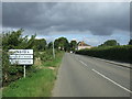
Entering Dunston
Heading north on Dunston Road.
Image: © JThomas
Taken: 5 Sep 2015
0.06 miles

5
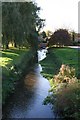
Stream alongside Dunston Fen Lane
Stream running alongside the road from Dunston village to Dunston Fen
Image: © Les Carruthers
Taken: 9 Nov 2006
0.23 miles
6
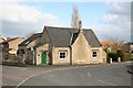
The Old School, Dunston
With a datestone of 1852
Image: © Richard Croft
Taken: 21 Mar 2007
0.23 miles
8
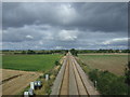
Railway towards Lincoln
Looking north west from the bridge on Dunston Road.
Image: © JThomas
Taken: 5 Sep 2015
0.23 miles
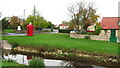
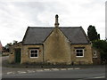
9

Dunston Brook
Idyllic village scene in Dunston
Image: © Richard Croft
Taken: 21 Mar 2007
0.23 miles